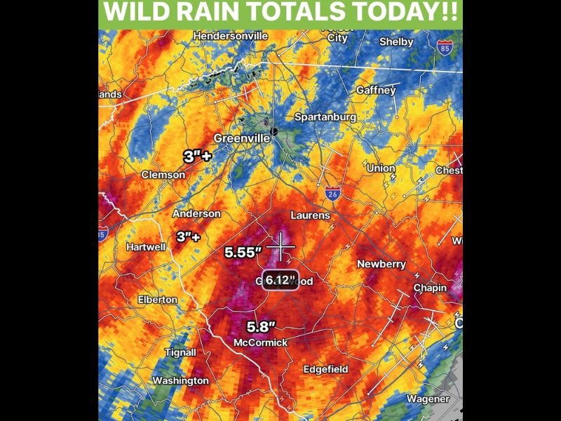
Wild Rain Totals Exceeding 6 Inches Drench Abbeville and Greenwood County South Carolina as Repeated Storms Streak 3 Plus Inch Pockets Across the Upstate Region
GREENWOOD, SC — Extraordinary and wide ranging rainfall totals have impacted the South Carolina Upstate region, with parts of Abbeville and Greenwood County recording over 6 inches of rainfall from repeated storm activity tracking across the area. Radar estimated rainfall totals show a striking and concentrated bull’s eye of extreme accumulations centered over the Greenwood corridor, with individual point totals of 6.12 inches near Greenwood, 5.55 inches just to the northwest, and 5.8 inches recorded near McCormick as the repeated storm training event delivered historic single day rainfall to the region.
Greenwood County Records Over 6 Inches as Repeated Storms Train Across the Same Areas
The highest rainfall totals across the South Carolina Upstate are concentrated in a focused zone centered over Greenwood County, where radar estimated accumulations reached 6.12 inches at the highest recorded point. The 5.55 inch total just northwest of Greenwood and the 5.8 inch reading near McCormick reflect the extraordinary concentration of rainfall across this relatively compact geographic zone as repeated storm cells trained over the same areas throughout the event.
The training storm pattern, where multiple individual cells move along the same track and repeatedly drop heavy rain over the same locations, is the meteorological mechanism responsible for the extreme accumulation totals recorded across Abbeville and Greenwood County during this event.
Three Inch Plus Totals Streak Across the Broader Upstate Region
Beyond the extreme bull’s eye totals near Greenwood, the broader Upstate South Carolina region recorded widespread rainfall accumulations of 3 inches or more across a large area. The Clemson and Anderson corridors both show 3 inch plus totals on the rainfall map, with the orange and red radar estimated precipitation shading covering a vast swath of the Upstate extending from Hendersonville and Greenville southward through Laurens, Newberry, and toward the Edgefield and Wagener areas.
Pockets of 3 inch totals are visible streaking across the entire region, reflecting the repeated and widespread nature of the heavy rainfall event across multiple Upstate South Carolina counties simultaneously.
Flash Flooding Concerns Elevated Across Abbeville Greenwood and Surrounding Counties
Rainfall totals of 5 to 6 inches accumulated over the course of a single day represent a serious and acute flash flooding threat for communities across Abbeville, Greenwood, and McCormick Counties. Low lying areas, river and stream corridors, and poor drainage zones across the affected region face elevated flood risk as the accumulated rainfall saturates soils and raises water levels across the Upstate watershed system.
Residents across all communities that received the heaviest rainfall totals are urged to avoid flooded roadways and monitor local flood guidance as water levels respond to the extraordinary accumulations recorded across the South Carolina Upstate. For continuing coverage of extreme rainfall events and flood threats across the United States, visit SaludaStandard-Sentinel.com.