Scattered Showers and Thunderstorms With Hail Possible Continue Through Overnight Across Colorado as Upper Level Jet Keeps Atmosphere Active Into Monday Morning
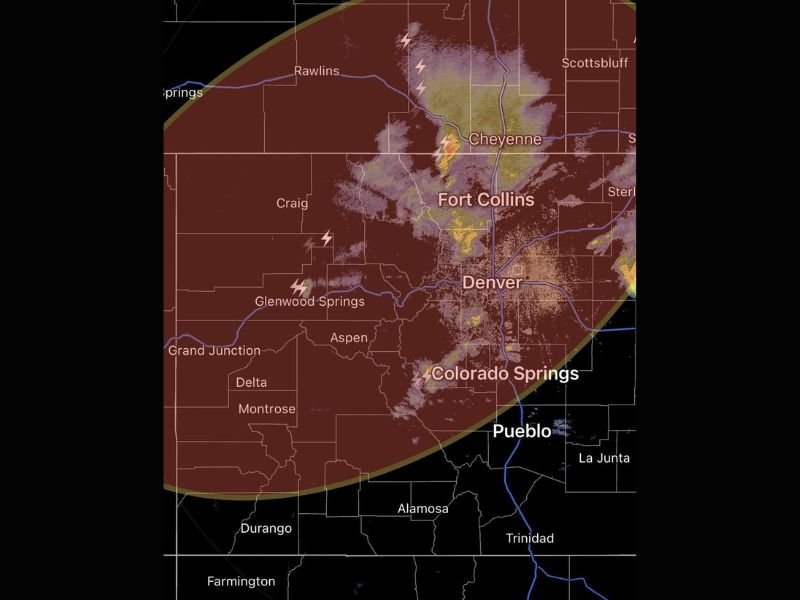
DENVER, CO — Scattered showers and thunderstorms are expected to continue through Sunday evening, overnight, and into Monday morning across a broad swath of Colorado as upper level atmospheric dynamics keep convective development active well after sunset. The Denver, Fort Collins, Colorado Springs, and Cheyenne corridors all fall within the active storm zone as the region remains positioned downstream of a trough and beneath the upper level jet stream, providing sufficient atmospheric lift to sustain shower and thunderstorm development through the overnight hours despite the loss of surface heating after dark.
Upper Level Jet and Trough Position Keep Storms Active Overnight Across Colorado
The persistence of shower and thunderstorm activity through the overnight hours is driven by the region’s position downstream of an upper level trough and directly beneath the upper level jet stream. These atmospheric dynamics provide continuous lift through a mechanism independent of daytime surface heating, meaning storm development across the Colorado Front Range and surrounding areas will continue generating new convective cells through the overnight period without requiring solar energy to maintain atmospheric instability.
Active storm returns are already visible across the Palmer Divide southwest of Denver and in adjacent areas, confirming that the atmospheric setup is already producing the expected overnight convective activity across the region as the evening progresses.
Hail Possible With Stronger Storms Though No Severe Weather Expected Overall
While the overall severe weather threat across Colorado is considered low through the overnight period, stronger individual storm cells carry the potential to produce hail as they develop and move through the region. No organized severe weather outbreak is anticipated with this particular setup, but residents across the Denver metro, Fort Collins, Colorado Springs, Pueblo, and Cheyenne areas should remain aware that hail producing storms are possible at any point through the overnight window.
The storm activity visible on radar across the Fort Collins and Cheyenne corridors shows scattered yellow and orange returns with lightning activity, consistent with moderately intense convective cells capable of producing small to possibly moderate hail with the stronger individual storm cores.
Main Storm System Set to Barrel Through Late Monday Morning and Afternoon
The overnight and early Monday morning shower and thunderstorm activity represents only the precursor phase of a more significant weather event developing for Colorado on Monday. The main storm system is forecast to barrel through the region during late Monday morning and into Monday afternoon, bringing a more organized and potentially impactful round of weather across the same broad area currently experiencing scattered overnight convection.
Residents across Denver, Fort Collins, Colorado Springs, Pueblo, and all surrounding Front Range communities are encouraged to monitor updated forecasts heading into Monday as the main storm system approaches and conditions become more active across the region through the day.
For continuing coverage of storm forecasts and overnight weather tracking across the United States, visit SaludaStandard-Sentinel.com.