Multiple Rounds of Heavy Rain and Possible Organized Severe Weather to Target Arkansas Sunday Night Through Wednesday as Dewpoints Soar to 70 Degrees and Instability Builds Monday May 18
LITTLE ROCK, AR — Arkansas faces a busy and potentially dangerous weather stretch beginning Sunday night and continuing through Wednesday, with multiple rounds of rain and storms carrying pockets of heavy rainfall expected across a moisture-loaded atmosphere, while Monday May 18 emerges as the day most likely to bring organized severe weather to the state as dewpoints climb into the low 70s and instability values surge across the region.
Dry Through Saturday Before Active Pattern Arrives
Residents across Arkansas will enjoy dry and pleasant conditions through Saturday before the active weather pattern arrives Sunday night. The transition from calm to active will be fairly abrupt, with multiple rounds of rain and storms developing Sunday night and continuing through Wednesday as a moisture-rich and increasingly unstable atmospheric setup takes hold across the state.
While rain will not fall continuously for three to four days straight, repeated times of rainfall are expected throughout the Sunday night through Wednesday period across Arkansas.
Heavy Rain Pockets Likely as Atmosphere Loads With Moisture
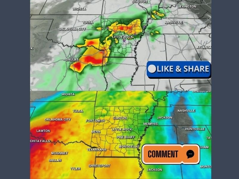
Arkansas Weather Network future dewpoint data valid for Monday 8:00 AM shows an exceptionally moist atmosphere in place across the state, with dewpoint readings of 70 to 72 degrees recorded from Texarkana and El Dorado northward through Little Rock, Pine Bluff, and into the northeastern Arkansas communities. Dewpoints in this range represent a very humid and moisture-laden atmosphere fully capable of supporting heavy rainfall production across the state.
Futurecast imagery valid for Monday May 18 at 7:58 AM shows intense precipitation returns concentrated directly over Little Rock and central Arkansas, with heavy rain cores extending westward toward the Oklahoma border.
Monday the Key Day for Organized Severe Weather
While severe weather concerns are not considered extremely high overall, Monday May 18 stands out as the day most likely to bring organized severe weather to Arkansas. Instability data valid for Monday 2:00 PM shows strong atmospheric fuel building across the state, creating conditions that could support more organized and potentially impactful storm development during the afternoon and evening hours across central and western Arkansas.
Residents statewide are urged to monitor updated forecasts closely through the weekend as details of the Sunday night through Wednesday active weather pattern continue to be refined.
For continuing coverage of severe weather events and critical storm analysis across the United States, visit SaludaStandard-Sentinel.com.