Historic Super El Nino Forecast to Shatter All Records by December 2026 With Ocean Temps 5 to 7 Degrees Above Normal Threatening Hotter US Summer Extreme Heatwaves and Stormy Gulf Coast Winter
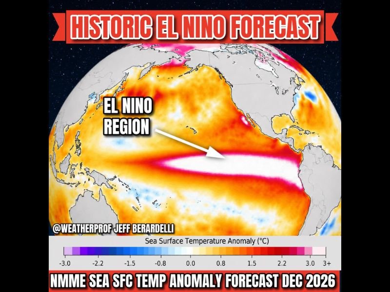
PACIFIC OCEAN — A potentially record-shattering Super El Nino event is being forecast by the NMME multi-model ensemble composite, with sea surface temperature anomalies projected to reach 3 to 4 degrees Celsius, or 5 to 7 degrees Fahrenheit, above normal across the El Nino region of the Pacific Ocean by December 2026, a reading that would break all existing El Nino records by a significant margin and carry profound weather consequences across the United States and globally.
NMME Model Signals Historic Record-Breaking El Nino
The North American Multi-Model Ensemble, a composite of numerous independent climate model forecasts, is projecting an extraordinary warming signal across the equatorial Pacific that would surpass every previously recorded El Nino event in modern meteorological history if it verifies by December 2026.
The sea surface temperature anomaly forecast imagery shows an intense band of above-normal ocean warmth stretching across the central and eastern equatorial Pacific, with the most extreme warming depicted in deep red and white tones indicating the highest temperature departure categories on the scale.
With substantial model support consistently pointing toward a very strong El Nino development, forecasters consider it very likely that a significant event is indeed developing across the Pacific.
US Summer to Run Hotter Than Average
Among the most direct impacts of a Super El Nino on the continental United States is the expectation of hotter than average temperatures across the country during the summer months. This above-normal heat signal, combined with the potential for more extreme heatwave episodes globally, raises significant public health concerns for communities across the US that already experience dangerous summer heat conditions during typical years.
The Southwest US is additionally forecast to see a wetter than normal summer monsoon season as a direct result of the developing El Nino pattern across the Pacific.
Stormy Gulf and Southeast Winter With Subdued Hurricane Season
Looking further into the forecast period, a Super El Nino would bring drought-busting heavy rainfall, flooding, and likely severe weather including tornadoes across the Southeast, Gulf Coast, and Florida beginning in November and continuing through the winter months. Simultaneously, the Atlantic Hurricane Season is expected to be subdued with fewer major storms, as El Nino-driven wind shear across the Atlantic typically suppresses tropical development during the summer and fall season.
Drought conditions are forecast across the Caribbean, Indonesia, and the Amazon with increased fire risk across those regions as the Super El Nino fully establishes itself through late 2026.
For continuing coverage of severe weather events and critical storm analysis across the United States, visit SaludaStandard-Sentinel.com.