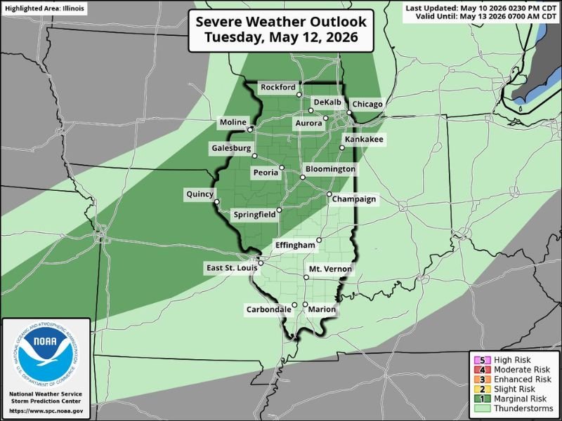
Damaging Wind Gusts and Hail Threaten Northern Illinois Tuesday Afternoon and Evening May 12 2026 Under Slight Risk From Rockford and Chicago Through Peoria and Springfield
CHICAGO, IL — A Slight Risk for severe weather has been issued by the Storm Prediction Center for northern Illinois on Tuesday, May 12, 2026, with damaging wind gusts and hail identified as the primary threats during the afternoon and evening hours across a broad corridor stretching from Rockford and Chicago southward through Aurora, Peoria, Springfield, and into the southern portions of the state.
Slight Risk Covers Broad Swath of Illinois Tuesday
The Level 2 Slight Risk designation from the Storm Prediction Center covers the majority of Illinois on Tuesday, reflecting a real but not widespread severe weather threat for the afternoon and evening timeframe. The risk zone encompasses a large geographic footprint across the state, placing major population centers including Rockford, DeKalb, Chicago, Aurora, Kankakee, Moline, Galesburg, Peoria, Bloomington, Champaign, Springfield, and East St. Louis all within the outlined severe weather potential area.
The outlook was last updated on May 10, 2026 at 2:30 PM CDT and remains valid through 7:00 AM CDT on May 13, 2026.
Damaging Wind Gusts the Primary Concern
Damaging wind gusts represent the headline threat associated with Tuesday’s severe weather potential across northern Illinois, with the strongest storm cells capable of producing gusts sufficient to down trees, damage structures, and cause power outages across communities within the risk zone.
Wind damage from severe thunderstorms during afternoon and evening hours tends to be particularly impactful across the densely populated northern Illinois corridor where urban infrastructure and tree coverage amplify the destructive potential of even moderate wind events.
Residents across the Rockford, Chicago, and Aurora corridor should be particularly attentive to storm timing as the afternoon severe weather window develops Tuesday.
Hail Adding to the Afternoon Severe Weather Threat
Hail accompanies the wind threat as a co-primary hazard across Illinois Tuesday afternoon and evening, with developing thunderstorm cells capable of producing hailstones sufficient to damage vehicles and outdoor property across the warned corridor. While the Slight Risk designation does not suggest a widespread or particularly intense hail event, isolated cells within the afternoon storm environment could produce hail capable of causing meaningful damage across localized areas of the state.
Residents with outdoor plans or vehicles left unsheltered across the northern and central Illinois corridor are advised to monitor storm development closely through the Tuesday afternoon and evening severe weather window.
For continuing coverage of severe weather events and critical storm analysis across the United States, visit SaludaStandard-Sentinel.com.