Heavy Rain Lightning and Gusty Winds Push East Through DFW Metroplex at 8:30 PM With Clearing Line Near Jacksboro and Mineral Wells as System Expected to Exit Within Hours
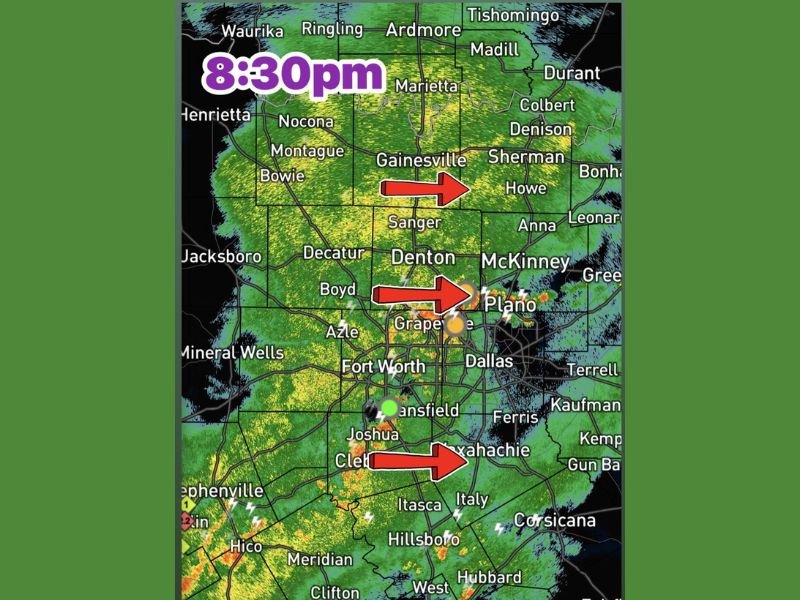
FORT WORTH, TX — A large batch of moderate to heavy rain accompanied by lightning and gusty winds is pushing eastward through the Dallas-Fort Worth Metroplex as of 8:30 PM Sunday, advancing through a broad corridor from Gainesville and Denton through Fort Worth, Grapevine, Plano, and Waxahachie, with a clearing line already established near Jacksboro and Mineral Wells indicating the system will exit the region within a couple of hours.
Heavy Rain and Lightning Pushing East Through DFW
Radar imagery captured at 8:30 PM shows widespread moderate to heavy precipitation blanketing the DFW Metroplex and surrounding communities, with the storm system advancing steadily eastward as indicated by three directional markers on the radar display pointing toward Sherman, Plano, and Waxahachie respectively.
Lightning activity is accompanying the heavier rainfall cores moving through the region, creating hazardous conditions for anyone outdoors across the affected metropolitan corridor during the evening hours.
The broad geographic coverage of the rain band means that communities from Gainesville and Denison in the north through Fort Worth and Dallas and southward toward Hillsboro and Corsicana are all experiencing the rainfall simultaneously as the system tracks east.
Gusty Winds Accompanying the Heavier Cells
Gusty winds are associated with the stronger rainfall cores pushing through the DFW area during the 8:30 PM timeframe, capable of creating brief and localized hazardous conditions across communities in the direct path of the heaviest precipitation bands. While the wind threat does not rise to the level of a severe thunderstorm warning across the metroplex at this time, gusty conditions can still impact driving visibility, down small branches, and create dangerous conditions for anyone caught outdoors during the system’s passage.
Motorists across the DFW area are advised to reduce speeds, increase following distances, and use headlights throughout the evening commute until the system fully clears the region.
Clearing Line Near Jacksboro and Mineral Wells Signals End in Sight
A defining and reassuring feature of the 8:30 PM radar picture is the clearing line already visible near Jacksboro and Mineral Wells to the west of the metroplex, indicating that the trailing edge of the rain system has already passed through those western communities. As the storm batch continues its eastward progression over the next couple of hours, conditions across Fort Worth, Dallas, and the broader DFW area are expected to improve progressively from west to east as the clearing line advances behind the departing rainfall.
Residents across the metroplex can expect conditions to return to normal within a couple of hours as the system exits the region entirely.
For continuing coverage of severe weather events and critical storm analysis across the United States, visit SaludaStandard-Sentinel.com.