80 MPH Winds and Baseball Size Hail Trigger Destructive Thunderstorm Warning for Grimes Madison and Walker Counties Texas Until 9 PM Sunday With Extremely Dangerous Conditions
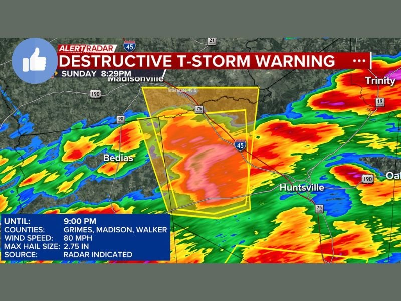
HUNTSVILLE, TX — A Destructive Thunderstorm Warning has been issued for Grimes, Madison, and Walker counties in Texas until 9:00 PM Sunday, May 10, as an extremely dangerous storm system produces radar-indicated wind speeds of 80 miles per hour and baseball size hail measuring 2.75 inches along the Interstate 45 corridor through Huntsville and Madisonville, demanding immediate shelter action from all residents within the warned counties.
Destructive Warning Covers Three Texas Counties Until 9 PM
The Destructive Thunderstorm Warning, the highest classification within the severe thunderstorm warning tier, covers Grimes, Madison, and Walker counties simultaneously until 9:00 PM Sunday evening. This designation confirms that the storm system impacting these counties is producing or expected to produce catastrophic damage across the warned area, well beyond what a standard severe thunderstorm warning would represent.
Radar imagery captured at 8:29 PM Sunday shows the warning polygon centered directly over the I-45 corridor between Madisonville and Huntsville, with the most intense storm returns concentrated within the heart of the three-county warning zone.
80 MPH Wind Speeds Confirmed Radar Indicated
Wind speeds of 80 miles per hour have been radar indicated with the destructive storm system, placing gusts in the range of a Category 1 hurricane equivalent for communities directly impacted along the warning corridor. Winds of this magnitude are capable of snapping large trees, collapsing outbuildings, downing power lines across wide areas, and causing significant structural damage to homes and businesses throughout Grimes, Madison, and Walker counties.
The radar-indicated source designation confirms that these wind speeds have been derived from Doppler radar data, reflecting the storm’s confirmed intensity across the warned zone.
Baseball Size Hail Adding to Catastrophic Damage Potential
Alongside the extreme wind threat, baseball size hail measuring 2.75 inches is confirmed with the destructive storm system. Hail of this size causes immediate and severe damage to vehicle exteriors, roofing materials, and windows across any community in the storm’s direct path, compounding the destruction already being driven by the 80 mph wind component simultaneously impacting the three warned Texas counties.
All residents across Grimes, Madison, and Walker counties are urged to seek shelter immediately in the lowest interior room of a sturdy structure and remain there until the warning expires at 9:00 PM Sunday.
For continuing coverage of severe weather events and critical storm analysis across the United States, visit SaludaStandard-Sentinel.com.