Damaging Winds Ping Pong Ball Hail and Frequent Lightning Strike the I-76 Corridor Between Fort Morgan and Crook Colorado as Outflow Boundary Gusts Hit 46 MPH Near Greeley
FORT MORGAN, CO — Severe storms are producing damaging winds, ping pong ball size hail, and frequent lightning across the Interstate 76 corridor between Fort Morgan and Crook in northeastern Colorado, as outflow boundary winds from the same storm system have already been clocked at 46 miles per hour near Greeley, confirming that the destructive reach of this storm complex extends well beyond the immediate warning polygon across the northeastern Colorado plains.
I-76 Corridor Facing Multiple Simultaneous Threats
The stretch of Interstate 76 between Fort Morgan and Crook sits directly within the most dangerous zone of the current storm complex, where the combination of damaging wind potential, ping pong ball size hail measuring approximately 1.50 inches, and extremely frequent lightning creates a compounding hazard environment for motorists and residents along the corridor.
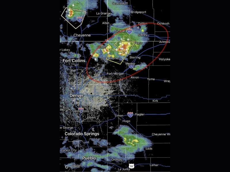
The warning polygon shown on radar is centered across the Raymer, Grover, and Peetz area, with the most intense storm cores producing the heaviest precipitation returns concentrated directly over this zone of northeastern Colorado. Travelers along I-76 in this stretch are strongly urged to exit the highway and seek substantial shelter immediately rather than attempting to outrun or drive through the warned storm cells.
Outflow Boundary Winds Already at 46 MPH Near Greeley
Confirming the broad and dangerous reach of this storm system, outflow boundary winds generated by the intense storm complex have already been measured at 46 miles per hour near Greeley, well southwest of the primary warning polygon. Outflow boundary winds occur when cold air from a storm’s downdraft spreads outward in all directions from the storm’s base, capable of producing damaging wind gusts across communities that are not even directly beneath the warned storm cells.
The 46 mph gust measurement near Greeley demonstrates that the destructive wind threat from this system extends across a significantly larger geographic footprint than the immediate warning area alone would suggest.
Large Red Circle Highlights Broader Threat Zone
Radar imagery shows a large red ellipse encompassing a broad area of northeastern Colorado including Sterling, Holyoke, Akron, and surrounding communities within an expanded threat zone beyond the immediate warning polygon. This broader highlight reflects the potential for additional storm development and outflow wind impacts across the wider northeastern Colorado plains region as the storm complex continues evolving through the afternoon and evening period.
Communities across Logan, Phillips, Yuma, and Washington counties all fall within or near this broader threat zone and should maintain active weather awareness through the storm event.
Motorists and Residents Urged to Seek Shelter Immediately
All residents and travelers across the Fort Morgan to Crook corridor and surrounding northeastern Colorado communities are urged to seek immediate shelter in a sturdy structure away from windows. Frequent cloud-to-ground lightning associated with these storms poses a life-threatening risk to anyone remaining outdoors, while the combination of damaging winds and large hail can cause rapid and severe damage to vehicles and structures across the affected zone.
For continuing coverage of severe weather events and critical storm analysis across the United States, visit SaludaStandard-Sentinel.com.