Level 1 Severe Outlook Issued for Western Hill Country and Edwards Plateau Texas Overnight With Storms Possible Near Rocksprings Moving East Northeast by Wednesday
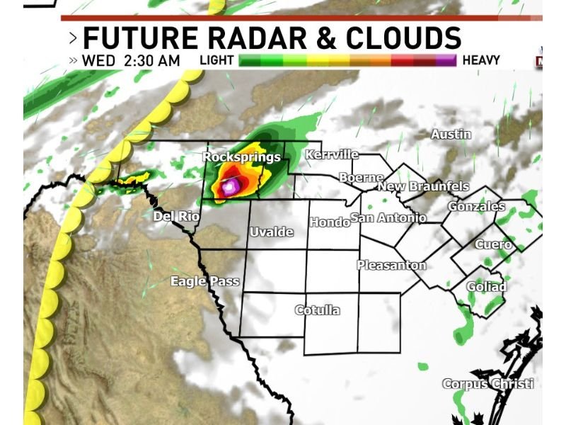
TEXAS — A Level 1 of 5 severe weather outlook has been issued for the western Hill Country and Edwards Plateau region of Texas overnight, with forecasters monitoring the potential for one or two storms to trigger off a retreating dryline across the area. Future radar projections valid at 2:30 a.m. Wednesday show the most intense storm activity concentrated near Rocksprings, with heavy precipitation already indicated in that corridor.
Retreating Dryline Could Spark Isolated Storm Development Overnight
The primary trigger for overnight storm development is a retreating dryline pushing westward across the Edwards Plateau region. One or two storms firing along this boundary could reach severe limits before the overnight hours conclude. While storm coverage is expected to remain isolated and limited, any storms that do develop have the potential to produce significant weather given the atmospheric setup in place across western Texas tonight.
Storms If They Develop Would Track East to Northeast
Any storms developing along the dryline tonight are forecast to move in an east to northeast direction, potentially tracking toward Kerrville, Boerne, and the broader Hill Country corridor as the overnight progresses. Residents across communities including Rocksprings, Del Rio, Uvalde, and Kerrville should remain weather aware through the overnight hours and into the early morning period on Wednesday.
Future Radar Shows Heaviest Activity Focused Near Rocksprings at 2:30 AM
Future radar projections indicate the heaviest storm activity centered near Rocksprings by 2:30 a.m. Wednesday, with lighter precipitation extending outward across surrounding areas. The overall storm threat remains a Level 1 of 5, meaning organized severe weather is not widely expected but isolated severe storms cannot be ruled out across the Edwards Plateau and western Hill Country zone tonight. For continuing coverage of severe weather events across the United States, visit SaludaStandard-Sentinel.com.