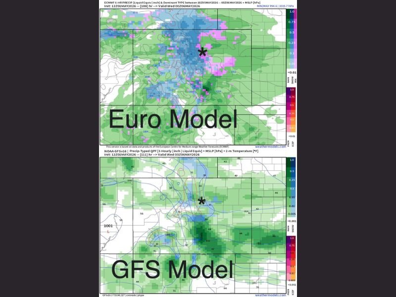
Desert Southwest Storm System and Cold Front to Bring Rain and Snow From Monday Through Wednesday With GFS and EURO Models Disagreeing on Temperatures and Timing
SOUTHWEST UNITED STATES — A new storm system moving out of the desert southwest combined with a cold front approaching from the north late Monday afternoon into Monday evening was expected to trigger a multi-day precipitation event stretching from Monday through Tuesday and into Wednesday, with both the GFS and EURO models agreeing on the overall synoptic pattern and general duration while disagreeing significantly on temperatures and precise timing details.
The EURO model was running colder with a broader snow footprint while the GFS trended warmer with more rain, leaving forecasters sorting through considerable model uncertainty heading into the weekend before a clearer picture was expected to emerge from updated forecast model data.
Two Forcing Mechanisms Drive the Monday Through Wednesday Event
The upcoming precipitation event was being driven by two distinct but related atmospheric features. A storm system pushing out of the desert southwest and a separate cold front dropping from the north were not expected to phase together into a single combined system, but both would serve as independent forcing mechanisms capable of generating precipitation across the region from Monday through Wednesday.
The party was expected to get started sometime Monday, continue through Tuesday, and persist into Wednesday as the two features moved through the region in sequence rather than simultaneously.
GFS and EURO Agree on Pattern but Diverge on Details
Both the GFS and EURO models along with most ensemble guidance were in general agreement on the broader synoptic weather pattern and overall duration of the precipitation event, providing forecasters with confidence in the general Monday through Wednesday timeframe. However, the two models diverged significantly on the colder versus warmer temperature solutions, with the EURO running colder and the GFS trending warmer, creating uncertainty around the rain versus snow distribution across the affected region.
The disagreement on timing between the two models added another layer of complexity to the forecast, making the weekend model runs critical for narrowing down the specific details of the Monday through Wednesday precipitation event.
Weekend Brings Pleasant Conditions Before Storm Arrives
Before the Monday system arrived, the weekend was forecast to deliver a notably pleasant break from the recent active pattern. Saturday in particular was described as near perfect, with warm and enjoyable conditions across the region before Sunday brought increasing winds ahead of the approaching Monday cold front.
Residents with barometric pressure sensitivities were advised to begin taking precautions on Sunday as winds picked up ahead of the frontal system, while the broader public was encouraged to enjoy the warm weekend window before the Monday through Wednesday precipitation event moved into the region.
For continuing coverage of weather events and critical storm analysis across the United States, visit SaludaStandard-Sentinel.com.