Scattered Showers and Isolated Thunderstorms Move Through Saluda, Columbia, Edgefield, and Augusta Overnight With Heaviest Rain Event of the Season Expected by Saturday
COLUMBIA, SC — A quick-moving front carrying scattered showers and the possibility of an isolated thunderstorm was forecast to push through the Saluda, Columbia, Edgefield, Augusta, and Orangeburg corridor late overnight into Thursday morning, delivering a wet commute to the region before rain ended by noon with temperatures settling around 78 degrees through the afternoon hours.
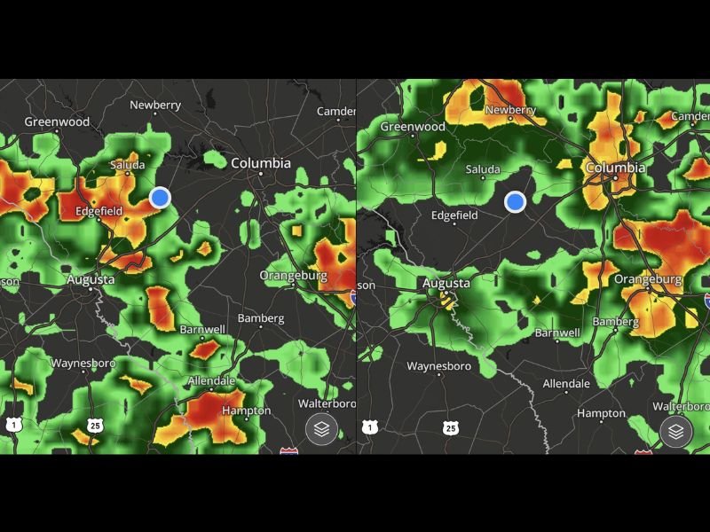
FutureCast imagery captured at 4 AM and 6 AM showed active precipitation cores concentrated across Saluda, Edgefield, and Augusta during the early morning hours, with shower coverage extending eastward through Columbia, Orangeburg, Bamberg, and Barnwell as the quick-moving frontal system pushed through the region.
Morning Commute Turns Wet Across the Region
The timing of the overnight frontal passage placed the most active shower activity squarely within the morning commute window for communities across the Midlands and CSRA region. Drivers heading to work and school across Saluda, Columbia, Edgefield, Augusta, Newberry, Greenwood, and surrounding areas were expected to encounter wet road conditions and reduced visibility through the early morning hours before the rain gradually ended approaching midday.
No severe weather was anticipated with the overnight and morning frontal passage, keeping the event within the category of a routine but impactful rain event for the region through the Thursday morning hours.
Rain Ends by Noon With Temperatures Near 78 Degrees
The quick-moving nature of the front meant that the rain was not expected to linger beyond the late morning hours across the affected communities. Rainfall was forecast to end by noon across the region, allowing afternoon conditions to improve with temperatures climbing to around 78 degrees through the remainder of Thursday.
The relatively brief duration of the rain event limited total accumulation potential while still delivering meaningful moisture across communities including Orangeburg, Bamberg, Barnwell, Waynesboro, Allendale, Hampton, and Walterboro within the broader precipitation footprint of the frontal system.
Heaviest Rain Event in a Long Time Expected Saturday
While Thursday’s rain event was described as a routine frontal passage, the more significant weather story for the region was developing for Saturday. The heaviest rain event seen in quite some time was forecast to arrive by Saturday, delivering widespread and potentially significant rainfall accumulations across the Saluda, Columbia, Augusta, and surrounding Midlands and CSRA communities.
The contrast between Thursday’s quick-moving scattered shower event and the heavier and more impactful Saturday rain system made the end of the week a critical weather monitoring period for residents across the entire region ahead of what was shaping up to be a notable rainfall event.
For continuing coverage of weather events and critical storm analysis across the United States, visit SaludaStandard-Sentinel.com.