Level 4 Moderate Risk Severe Storms With EF2 Tornadoes, Softball-Size Hail and 70 MPH Winds to Strike Oklahoma and North Texas This Afternoon Into Overnight
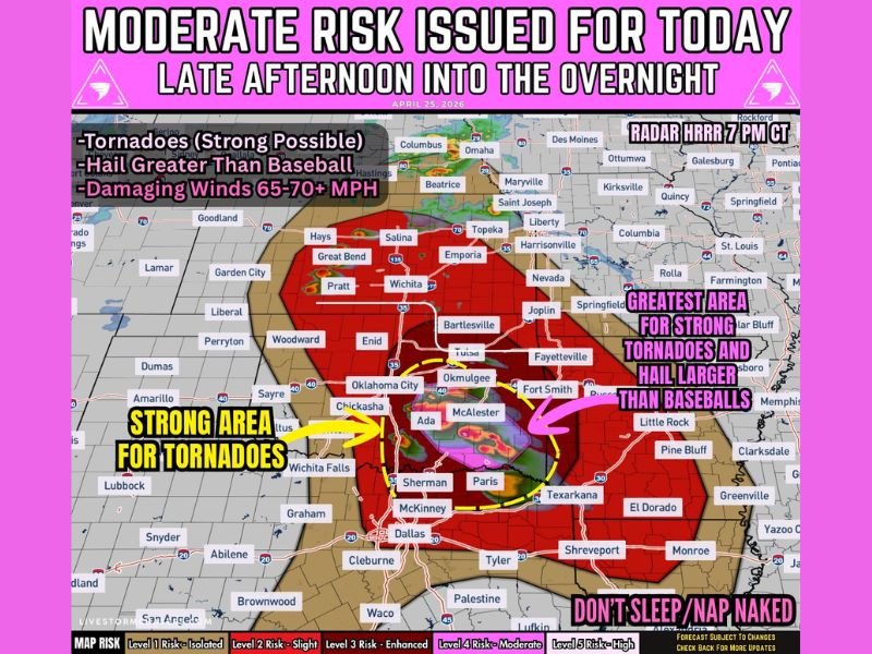
OKLAHOMA — A life-threatening Level 4 Moderate Risk severe weather event is targeting the southern Plains today, with Oklahoma and North Texas directly in the path. Dangerous supercells capable of producing strong EF2 tornadoes, giant hail, and winds of 65 to 70 miles per hour will develop from late afternoon and continue into the overnight hours. Residents are urged to have multiple ways to receive warnings and stay alert through the night.
Where the Danger Is Greatest
Southern Oklahoma into north Texas carries the highest tornado concentration today. Cities including Oklahoma City, Chickasha, Ada, McAlester, Sherman, Paris, and the Texarkana corridor are in the strongest tornado and oversized hail zone.
The Tulsa, Fort Smith, and Fayetteville corridor to the northeast also sits in a highlighted danger area. Further north, Wichita, Pratt, and Salina in Kansas face significant hail and damaging wind threats throughout the day.
Three Major Threats on the Table
Giant hail reaching baseball to locally softball size is possible with the strongest supercells, posing serious danger to vehicles, rooftops, and anyone outdoors.
Damaging winds of 65 to 70 miles per hour or greater will increase as storms cluster and push southeast into the ArkLaTex through the evening. Strong tornadoes, some potentially reaching EF2 intensity, are most likely across southern Oklahoma into north Texas where supercell conditions are most favorable.
Timeline to Know
Storms fire across north Texas and Oklahoma during the afternoon. Late afternoon through evening brings the peak window for supercells with giant hail and tornadoes. Overnight, storms push into the ArkLaTex with continued wind and tornado risk through the night.
Stay Alert Through the Night
Forecasters are clear — do not sleep through this threat. Have weather radio, phone alerts, and local broadcasts all active. The danger continues well past sunset across the ArkLaTex region.
Identify your safe room now and be ready to move immediately when warnings are issued in your county. Share your storm reports at SaludaStandard-Sentinel.com.