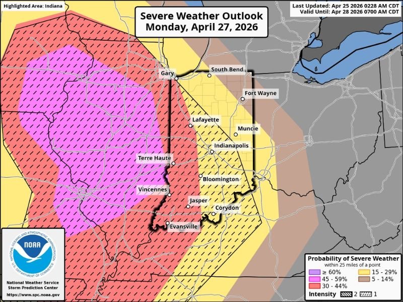
Enhanced Risk Severe Storms Threaten Illinois and Indiana Monday With Wind, Hail and Tornadoes Possible Across Central IL and Cities Including Terre Haute, Evansville, Indianapolis and Gary
ILLINOIS — Most of the region is now under an Enhanced Risk of severe weather heading into Monday and Monday night, with forecasters warning that all hazards including damaging winds, large hail, and tornadoes will be possible across a wide area spanning Illinois and Indiana. The highest concentration of the strongest storms is expected to develop across much of central Illinois.
Timing indicates storms will fire by early to mid-afternoon in western Illinois before pushing east through the evening hours and into Monday night.
Who Faces the Highest Risk
Central Illinois sits at the core of the Enhanced Risk zone, where storm activity is expected to be most intense and widespread. Cities including Terre Haute, Vincennes, and Evansville on the Indiana side, along with Gary to the north, all fall within the elevated threat area.
Further east across Indiana, cities including Indianapolis, Lafayette, Muncie, Bloomington, Jasper, and Corydon sit within a slight risk zone where scattered severe storms remain possible as the system moves through.
All Three Hazards on the Table
This is not a single-threat event. Forecasters are emphasizing that wind, hail, and tornadoes are all possible with the strongest storms that develop Monday. That combination of hazards means residents across the entire risk area need to be prepared for multiple types of severe weather impacts rather than focusing on just one threat.
Damaging winds can down trees and knock out power across wide areas. Large hail poses serious risk to vehicles and property. Tornado potential, even if isolated, demands that residents know their shelter location well before storms arrive.
What to Expect Monday and Into the Night
Storms are expected to develop in western Illinois during the early to mid-afternoon hours and track eastward through the rest of the day and into Monday night. Residents should be weather aware well before afternoon and remain alert through the overnight hours as the system continues pushing east.
More forecast updates are expected throughout the weekend as the storm system comes into sharper focus. Risk zone boundaries and timing could still shift, so staying connected to updated forecasts before Monday is strongly advised. Stay informed and share your storm reports with the community at SaludaStandard-Sentinel.com.