Severe Storm Complex Approaching Tulsa Oklahoma With Damaging Winds, Very Heavy Rain and Spin-Up Tornado Possible as Storms Track Through Stillwater, Pawnee and Skiatook
TULSA, OKLAHOMA — A severe storm complex is approaching the Tulsa metro area and is expected to arrive within the next couple of hours as of 10:15 PM. Forecasters are warning that the main risks from this system are damaging winds and very heavy rain, though a spin-up tornado cannot be ruled out as the storm complex pushes eastward toward the Tulsa metropolitan area. All residents in and around Tulsa are urged to seek shelter immediately and remain in a safe location until the storms pass.
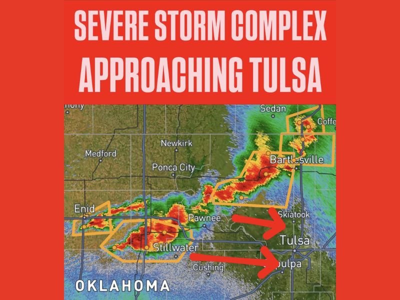
Radar imagery shows intense red and orange returns tracking directly toward Tulsa from the west and northwest, with the storm complex currently impacting communities including Enid, Stillwater, and Pawnee.
Current Storm Position and Immediate Threat Zone
As of 10:15 PM, the severe storm complex is located across a corridor stretching from near Enid eastward through Pawnee and toward Skiatook and the northern Tulsa suburbs. The radar display shows two primary warning polygons outlined in orange, covering separate cells within the complex that are both tracking toward the Tulsa metro area.
The red arrows on the radar map clearly indicate the eastward track of the storm system, with one storm line targeting Tulsa directly and a second track pointing toward Sapulpa just south of the city. Bartlesville to the north is also within an active warning area as a separate portion of the complex pushes through that corridor.
Primary Hazards Heading Into Tulsa Tonight
Forecasters are identifying two primary hazards associated with this storm complex as it approaches Tulsa. Damaging winds are the headline threat, capable of downing trees, power lines, and causing significant structural damage across the metro area. Very heavy rainfall accompanying the storm complex could lead to rapid water accumulation on roadways and in low-lying areas.
Additionally, while not the primary concern, forecasters have explicitly stated that a spin-up tornado cannot be ruled out within this storm complex. Residents should treat this as a potential tornado-producing event and seek interior shelter on the lowest floor of a sturdy building immediately.
Communities in the Direct Path Tonight
Based on current radar data and storm track, communities directly in the path of this severe storm complex include Skiatook, Tulsa, and Sapulpa as the primary targets over the next couple of hours. Bartlesville and surrounding communities in Washington County to the north are also within active warning areas from the northern portion of the storm complex.
Stillwater, Pawnee, and Cushing have already been impacted or are currently experiencing severe weather conditions as the complex continues its eastward push toward the Tulsa metro area.
Immediate Safety Actions for Tulsa Residents
All residents across the Tulsa metro area should move to interior shelter immediately and not wait for conditions to deteriorate before taking action. Stay away from windows, avoid low-lying areas prone to flooding, and do not attempt to drive through water covered roadways. Monitor local emergency broadcasts and weather alert devices for any updated warnings or tornado declarations as the storm complex arrives.
Are you in the Tulsa metro area tracking this approaching severe storm complex? Stay in shelter and stay informed with the latest coverage at SaludaStandard-Sentinel.com.