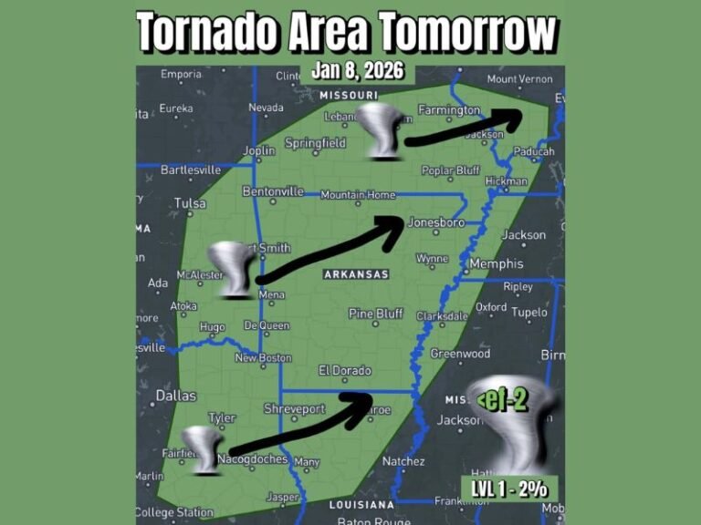
Severe Storm System Threatens Central Oklahoma Saturday With Baseball-Size Hail, 80 MPH Winds and Isolated Strong Tornadoes Active From 3 PM Through Early Sunday Morning
OKLAHOMA — A dangerous storm system is taking shape across central Oklahoma as a warm front pushes through the region Saturday, bringing with it a significant threat of severe weather that forecasters say could impact hundreds of thousands of residents. Meteorologists are tracking the development closely, warning that conditions will become increasingly dangerous from 3:00 PM Saturday through the early morning hours of Sunday, with hail, extreme winds, and isolated tornadoes all on the table.
The warm front setting up from northwest through central Oklahoma is creating a volatile boundary along which the strongest storms are expected to fire. While not every resident in the affected region will experience severe weather directly, the potential for life-threatening conditions is real enough that forecasters are urging all residents within the risk zones to remain alert and have a safety plan ready well before the afternoon hours arrive.
Threat Levels Across the State
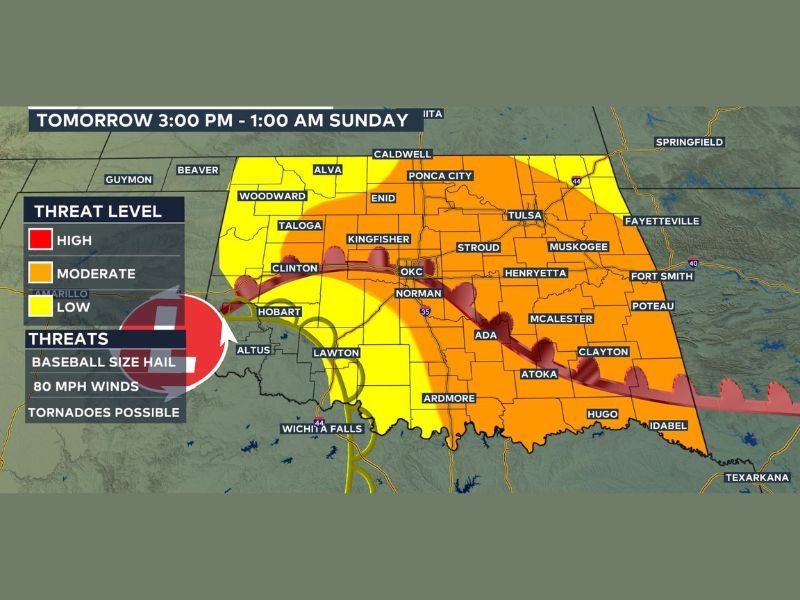
The storm risk is divided into three distinct tiers covering much of Oklahoma. A high-risk zone sits in portions of southwestern Oklahoma, centered near the Hobart and Clinton areas, where the most dangerous storm ingredients are expected to converge. A broad moderate-risk zone stretches across central and south-central Oklahoma, covering Oklahoma City, Norman, Lawton, Ada, Ardmore, Atoka, and McAlester among other communities. A lower-level threat extends into the wider surrounding region, including areas around Enid, Woodward, Ponca City, Tulsa, Muskogee, and portions of southeastern Oklahoma near Hugo and Idabel.
Forecasters caution that the boundaries between these risk tiers remain subject to change as the warm front continues to evolve. Residents in any of the affected zones are advised not to assume they are out of danger based on early forecast maps, and should continue monitoring updated guidance throughout Saturday morning.
Three Major Hazards Expected
The storms developing along this front carry three serious threats. Hail up to baseball size, reaching approximately three inches in diameter, is possible with the strongest cells, posing significant risk to vehicles, property, agriculture, and anyone outdoors. Wind gusts of up to 80 miles per hour could accompany severe thunderstorms, strong enough to topple trees, damage structures, and knock out power across wide areas of the state. Isolated strong tornadoes also cannot be ruled out, particularly across the high-risk southwestern zones where atmospheric instability will be at its greatest.
Residents should note that these threats can occur in combination, meaning a single storm could bring damaging winds, large hail, and tornado conditions within minutes of one another. The speed at which conditions can deteriorate makes early preparation essential rather than optional.
How to Stay Safe Saturday
Meteorologists are not telling residents to cancel their plans, but they are urging everyone in the affected areas to stay informed and act quickly if conditions change. Before 3:00 PM, residents should identify an interior shelter on the lowest floor of a sturdy building, charge phones and devices, and make sure weather alerts are enabled. Those planning outdoor activities should keep a close eye on radar and be ready to move indoors immediately if storms approach.
When a tornado warning is issued, waiting to hear or see the storm before taking shelter is not advisable. A sudden shift in wind, darkening skies, or a low rumbling sound are all signals to act immediately. Large hail often precedes the most violent storm activity and can serve as an early warning that conditions are rapidly intensifying nearby.
Full Coverage Planned Through the Evening
Weather teams across Oklahoma are preparing comprehensive coverage of this system beginning Saturday morning, with continuous on-air and online updates as the front moves through. The full risk picture, including any shifts in timing or the geographic threat area, will be updated throughout the day as new data becomes available. Residents are encouraged to tune in to local broadcasts and follow official emergency management channels for the most current information.
If you witnessed storm damage, captured hail, or experienced severe weather conditions in your area Saturday, the Saluda Standard-Sentinel wants to hear from you. Share your reports and stay connected with your community at SaludaStandard-Sentinel.com for continued coverage of this storm system and all developing weather across the region.