Significant Severe Weather Threat Forecast Sunday as Classic Dryline Setup Fires Intense Supercells Across the Southern Plains With Very High Ceiling for Dangerous Storms
SOUTHERN PLAINS — A classic plains severe weather setup is locked in for Sunday, and forecasters are describing this event as having a very high ceiling for dangerous storm development. Once storms fire along the dryline, they could rapidly explode into intense supercells capable of producing significant severe weather across the Southern Plains during the afternoon and evening hours.
The combination of strong instability and wind shear already in place means that any storm managing to stay isolated will have the potential to become extremely dangerous very quickly, making Sunday a day that demands serious attention from residents across the entire threat zone.
The Dryline Setup Explained
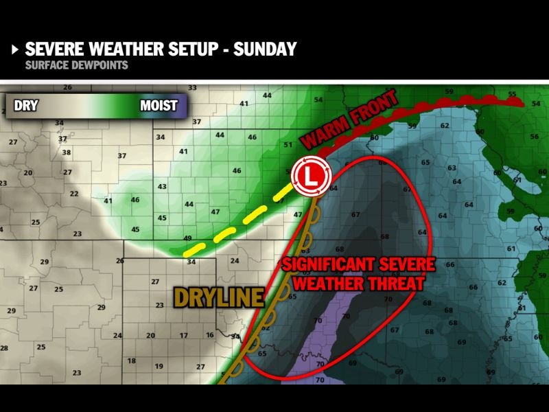
The forecast map from Max Velocity shows the critical ingredients coming together Sunday in textbook fashion. A well-defined dryline is oriented along a north-to-south axis across the Southern Plains, serving as the primary trigger boundary where dry air from the west collides with deeply moist air pushing northward from the Gulf of Mexico.
Surface dewpoints in the moist sector are running in the mid to upper 60s and low 70s across the threat zone, providing exceptional fuel for explosive storm development. The low-pressure center positioned near the dryline intersection will further enhance lift and storm initiation potential during the afternoon hours.
Significant Severe Weather Threat Zone
The area of most significant concern on Sunday is clearly marked on the forecast map, encompassing a broad corridor across the Southern Plains where the dryline, warm front, and surface low are all converging. This overlap of multiple boundary types creates an environment forecasters describe as a very high ceiling event, meaning storms that develop in this zone have the atmospheric support to reach their most intense and dangerous potential.
Any supercell that stays discrete and isolated within this zone will have access to extreme instability and strong wind shear, two ingredients that together support large hail, damaging winds, and significant tornado development.
Rapid Storm Intensification Is the Primary Concern
One of the most dangerous aspects of Sunday’s setup is how quickly storms could intensify once they initiate along the dryline. Forecasters are specifically warning that storms could rapidly explode into intense supercells shortly after firing, leaving little time for residents to react if they are not already prepared and sheltered before storm development begins.
This rapid intensification potential makes early preparation and proactive shelter decisions critically important for anyone living within the threat zone Sunday afternoon.
What Residents Should Do Before Sunday
Residents across the Southern Plains threat zone are urged to finalize all severe weather preparations before Sunday arrives. Identifying a sturdy shelter location, charging weather alert devices, downloading local emergency apps, and avoiding unnecessary outdoor exposure during the peak afternoon and evening storm window are all essential steps.
Given the very high ceiling described by forecasters for this event, treating Sunday with the same seriousness as a confirmed outbreak day is the safest approach for all communities within reach of the dryline.
Are you preparing for Sunday’s significant severe weather threat across the Southern Plains? Share your plans and stay informed with the latest coverage at SaludaStandard-Sentinel.com.