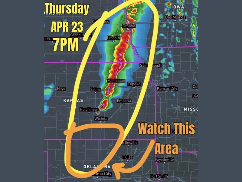
Severe Storms and Supercell Threat Erupts Across Nebraska, Kansas and Oklahoma Along Dryline Thursday April 23 With Damaging Winds and Embedded Circulations Expected by 7 PM
NEBRASKA — Widespread severe storms are forecast to erupt along a dryline stretching from around Omaha, Nebraska southward into Oklahoma on Thursday, April 23, with the primary storm activity expected to develop by 7 PM. Forecasters are closely watching a corridor spanning Nebraska, Kansas, and Oklahoma where atmospheric conditions are favorably aligned for a significant severe weather event during the evening hours.
The storm threat carries two distinct flavors depending on location, with the northern and southern portions of the dryline presenting different but equally concerning severe weather scenarios for communities across the region.
Northern Dryline Threat From Omaha Through Kansas
Across the northern portion of the dryline, from Omaha and Lincoln southward through Manhattan, Topeka, Salina, and toward Kansas City, forcing is described as greater and more well-defined. This stronger forcing is expected to promote quick upscale storm growth into linear modes, meaning storms could rapidly organize into a fast-moving line capable of producing widespread damaging winds and embedded circulations.
Communities including Columbus, Grand Island, Manhattan, Emporia, and Hutchinson all fall within this northern threat corridor. Residents from Omaha through central Kansas should be prepared for rapidly developing storm activity during the evening hours Thursday.
Southern Dryline Presents Significant Supercell Danger
Further south across Oklahoma, including Tulsa, Oklahoma City, and Bartlesville, the atmospheric setup shifts in character. Forecasters note that while forcing is more nebulous with a strong cap in place across the southern portion of the dryline, instability will be considerably greater in this region.
If storms can initiate across southern Kansas and Oklahoma, forecasters warn they may easily become significant supercells capable of producing large hail, damaging winds, and tornadoes. Forecasters are specifically cautioning that high-resolution models often struggle to initiate storms in capped environments, meaning the threat should not be discounted simply because storm activity is not explicitly shown on every model run.
Key Communities in the Watch Area
The primary watch area for Thursday evening encompasses a broad swath of communities across three states. In Nebraska, Omaha, Lincoln, Columbus, and Grand Island are all within the threat zone. Across Kansas, Manhattan, Topeka, Salina, Hutchinson, Wichita, and Kansas City fall within the watch corridor.
In Oklahoma, Oklahoma City, Tulsa, Bartlesville, and Fort Smith in neighboring Arkansas are all within the southern portion of the area forecasters are monitoring closely for potential supercell development during the evening hours.
What Residents Should Do Before Thursday Evening
With Thursday’s storm threat still developing, residents across Nebraska, Kansas, and Oklahoma have time to prepare before the 7 PM window arrives. Identifying a safe shelter location, charging weather alert devices, and staying connected to updated local forecasts throughout the day Thursday are all critical steps for anyone living within the dryline threat corridor.
The combination of damaging winds in the north and supercell potential in the south makes this a multi-faceted severe weather event that demands attention across the entire region.
Are you tracking Thursday’s severe weather threat across Nebraska, Kansas, or Oklahoma? Share your preparations and stay informed with the latest coverage at SaludaStandard-Sentinel.com.