Flooding Emergency Unfolds Across South Central Texas as San Antonio and New Braunfels Region Records Up to 8 Inches of Rain With No End in Sight
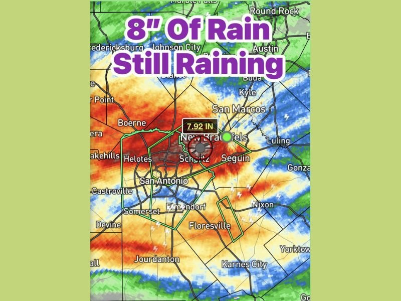
SOUTH CENTRAL TEXAS — A dangerous and ongoing flooding situation is developing across South Central Texas as relentless rainfall continues to pound the region throughout the day with no immediate signs of letting up. Spots across the affected area have already recorded up to 8 inches of rain, with radar data showing a reading of 7.92 inches near New Braunfels, and flooding is rapidly becoming a major and widespread concern across the San Antonio metro and surrounding communities.
The storm system has been producing heavy rainfall all day, saturating the ground and overwhelming drainage infrastructure across one of Texas’s most densely populated regional corridors.
8 Inches of Rain and Still Falling
The rainfall totals emerging from South Central Texas are alarming. Near New Braunfels, radar-estimated totals have already reached 7.92 inches, with broader reports of spots crossing the 8-inch mark across the region. Communities including San Antonio, Schertz, Seguin, Boerne, Helotes, Floresville, and Castroville all fall within the heaviest rainfall zone shown on current radar imagery.
Rain is continuing to fall across the same already-saturated areas, meaning totals will continue to climb and flood conditions will only worsen until the storm system finally moves out of the region.
Flooding Becoming a Major Issue Across the Region
With ground already saturated from all-day rainfall and totals reaching 8 inches in some locations, flooding is actively developing and escalating across South Central Texas. Low-lying roads, underpasses, creeks, and rivers are at serious risk of flooding or may already be flooded in the hardest-hit zones near San Antonio and New Braunfels.
Residents across the affected area should avoid all unnecessary travel and under no circumstances attempt to drive through flooded roadways. Even shallow moving water on roadways can sweep vehicles off course, and flood conditions can develop rapidly without warning across this region.
Communities Across the San Antonio Corridor at Risk
The radar footprint of the heaviest rainfall covers a broad and heavily populated swath of South Central Texas. Beyond San Antonio and New Braunfels, communities including Schertz, Seguin, Helotes, Somerset, Floresville, Jourdanton, and areas stretching toward Karnes City and Nixon all fall within the zone of significant rainfall accumulation.
Local emergency management agencies across the affected counties are monitoring the situation closely, and residents should stay tuned to official weather alerts and local emergency broadcasts for the latest flood warnings and evacuation guidance as this dangerous situation continues to evolve.
Is your community experiencing flooding in South Central Texas right now? Share your situation and stay safe by following updates at SaludaStandard-Sentinel.com.