Oklahoma, Kansas, Wisconsin, Iowa, and Illinois Face Multi-Mode Severe Weather Outbreak With Long-Track Tornadoes and Destructive Winds Expected on Friday
OKLAHOMA TO WISCONSIN — A widespread and dangerous multi-mode severe weather outbreak is forecast for Friday afternoon across a corridor stretching from Oklahoma all the way north through Kansas, Iowa, Illinois, and into Wisconsin. Damaging winds, large hail, and strong long-track tornadoes are all expected, with forecasters identifying two specific high-priority corridors carrying the greatest tornado potential as the most dangerous zones for Friday’s event.
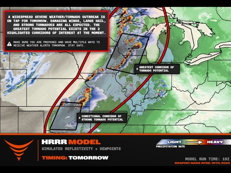
The HRRR model simulated reflectivity data prepared April 16, 2026, showed an expansive storm complex developing along this corridor, with the outbreak expected to unfold in multiple modes throughout the afternoon and evening hours.
Two High Priority Tornado Corridors Identified
Forecasters have pinpointed two specific corridors carrying the greatest tornado threat for Friday. The primary and most dangerous corridor covers southern Wisconsin, northern Illinois, and eastern Iowa, where the strongest low-level wind shear is expected to develop on the northern end of the warm sector ahead of a surface low pressure system. This environment is highly favorable for long-track tornado development, meaning individual tornadoes could stay on the ground for extended distances and durations.
The second corridor is a conditional threat zone covering Oklahoma and southern Kansas, where a strong tornado is possible ahead of a crashing cold front and dry line interaction. While this threat is dependent on atmospheric conditions coming together favorably, the environment could support a significant tornado if storms develop in the right configuration.
Destructive Wind Bag Threat Between the Two Corridors
Between the two primary tornado corridors, the dominant threat shifts to what forecasters described as a destructive wind bag — a zone where a linear storm mode will produce the most widespread and damaging straight-line wind impacts across the region. This middle zone covering portions of Missouri, central Illinois, and surrounding areas faces the highest probability of experiencing widespread wind damage as storm lines consolidate and push eastward throughout Friday afternoon and evening.
Residents in this zone between the two tornado corridors should not underestimate the wind threat, as straight-line winds from an organized squall line can be just as destructive as a tornado across a much wider geographic area.
Prepare Now With Multiple Alert Methods
With a multi-mode outbreak of this magnitude expected, forecasters issued an urgent reminder for all residents across the affected corridor to have multiple ways to receive weather alerts active before Friday afternoon arrives. A single method of receiving warnings is not sufficient for an event of this scope and danger level.
All residents from Oklahoma through Wisconsin should identify shelter locations, charge devices, and monitor forecast updates throughout Friday morning as the situation evolves.
Are you in the path of Friday’s multi-mode severe weather outbreak? Stay prepared and follow our continuing coverage at SaludaStandard-Sentinel.com.
Author: Saluda Standard-Sentinel Team | Category: US News