Michigan Upper Peninsula Faces Severe Weather Threat Friday Night With Hail Risk, Tornadoes And Damaging Winds From 8 PM Through 3 AM Saturday
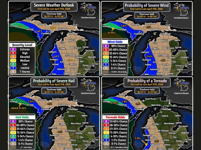
MICHIGAN — A potent severe weather system is set to blast through Wisconsin and push into Michigan’s Upper Peninsula Friday night, with forecasters issuing a first call severe weather outlook valid from 8 PM Eastern Friday through 3 AM Eastern Saturday. The southwestern Upper Peninsula is under the greatest threat, with residents urged to prepare for severe weather at any point beyond 6 to 7 PM Central time as storms move northward from the Wisconsin border region.
The system carries the full suite of severe weather hazards including tornadoes, damaging winds, and large hail, with the threat beginning as discrete supercells before consolidating into a damaging wind-producing squall line through the overnight hours.
Tornado and Hail Threat for Southwestern Upper Peninsula
The southwestern corner of the Upper Peninsula near Ironwood carries the highest severe weather risk, rated at Level 2 out of 6 on the severity scale. Tornado probability in this zone reaches 4 to 10 percent, with EF-2 or stronger tornadoes specifically highlighted as possible. Hail odds in the Ironwood area reach 5 to 14 percent with hail of 2 inches or larger considered likely in the hatched zone.
As storms develop and move northward from central Wisconsin into the Wisconsin-Michigan border region, supercells will bring the tornado and large hail threat before eventually consolidating into a line with damaging winds becoming the primary hazard.
Damaging Wind Probability Across the Region
Severe wind probability maps showed the highest wind odds of 5 to 14 percent concentrated across the southwestern Upper Peninsula near Ironwood and Iron River. The remainder of the Upper Peninsula and much of the Lower Peninsula carries wind probabilities below 4 percent, with 75 mph or stronger winds considered possible within the highest risk zone during the overnight hours.
Once the supercell phase transitions to a squall line, widespread damaging winds will become the dominant threat pushing eastward along the US-131 corridor, which forecasters identified as the current eastern extent of the severe weather threat for Friday night into Saturday morning.
Timeline and What Residents Should Do
The severe weather window runs from 8 PM Eastern Friday through 3 AM Eastern Saturday, with sub-severe storms continuing across eastern Michigan through sunrise Saturday morning. Residents in the southwestern Upper Peninsula should complete all preparations before 6 PM Friday and remain weather-aware through the entire overnight period.
Those in Ironwood, Iron River, Escanaba, and surrounding communities should have multiple warning alert methods active and identify shelter locations in advance of storm arrival Friday evening.
Are you in Michigan’s Upper Peninsula preparing for Friday night’s severe weather? Stay safe and follow our updates at SaludaStandard-Sentinel.com.