Wisconsin, Iowa, Kansas, and Oklahoma Face TORCON 5 Tornado Outbreak Friday With EF-3 Twisters and Hurricane Force Winds Possible
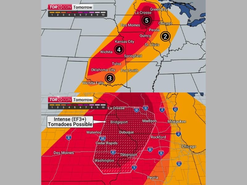
WISCONSIN AND IOWA — Friday is shaping up to be an extraordinarily dangerous severe weather day across a broad corridor stretching from Oklahoma through Kansas, Iowa, and into Wisconsin, with TORCON values reaching as high as 5 in Wisconsin and Iowa and TORCON 4 surrounding that zone. Forecasters are warning that intense EF-3 or stronger tornadoes, large hail, and hurricane-force straight-line winds are all possible as a classic springtime severe weather setup unfolds across the region.
The threat begins with individual supercell storms during the afternoon hours before transitioning into a dangerous straight-line wind event as a strong cold front pushes east through the evening, creating a two-phase severe weather threat that could impact millions of residents across multiple states.
TORCON Values Signal Extreme Tornado Danger
TORCON values mapped across the region Friday tell a concerning story about the tornado threat level. Wisconsin and Iowa sit at the highest TORCON value of 5, with a TORCON 4 surrounding that core zone covering Kansas City and Wichita. Oklahoma City, Wichita Falls, Tulsa, and Fort Smith carry a TORCON 3, while areas further east including Peoria and communities in Illinois register a TORCON 2.
Within the highest risk zone, intense EF-3 or stronger tornadoes are specifically highlighted as possible across a corridor covering La Crosse, Bridgeport, Waterloo, Cedar Rapids, Dubuque, Davenport, Madison, Rockford, and surrounding communities across Iowa and Wisconsin.
Two-Phase Severe Weather Threat Friday
The afternoon hours will initially favor discrete supercell development, which is precisely when the tornado and large hail threat will be greatest. Moisture flowing freely from the Gulf of Mexico combined with moderate wind shear and strong upper-level support creates an incredibly favorable environment for supercell thunderstorms capable of producing violent tornadoes.
As evening arrives, storms are expected to squall out and merge into an intense straight-line wind event as the cold front accelerates eastward. Winds during this phase could gust to hurricane force, capable of causing widespread tree damage and significant power outages across the entire affected corridor.
Prepare Now Before Friday Afternoon Arrives
Residents across Wisconsin, Iowa, Kansas, Oklahoma, and surrounding states must complete all severe weather preparations before noon Friday. Identify your shelter location, charge all devices, and activate weather alert notifications immediately.
The cold front pushing through will drop weekend temperatures by approximately 20 degrees behind the severe weather, bringing sunshine and calm skies Saturday — but Friday demands the utmost caution and preparation from everyone in the risk zone.
Are you in Friday’s severe weather threat zone? Share your preparations and stay informed at SaludaStandard-Sentinel.com.