North Carolina Near Record Heat and High Wildfire Danger Thursday as Temperatures Soar Into the 80s and 90s Statewide
NORTH CAROLINA — A summer-like heat surge is gripping North Carolina on Thursday, April 16, 2026, with temperatures expected to reach the 80s and 90s across most of the state under partly to mostly sunny skies. The unseasonably hot and dry conditions are simultaneously elevating wildfire danger to a high level, with exceptionally dry fuels, low relative humidity, and gusty southwest winds combining to create dangerous fire weather conditions across the region.
Forecasters described the heat as a drier variety compared to typical Carolina warmth, meaning humidity levels will remain relatively low and make the day feel more like a classic summer afternoon than a humid spring day, though the fire risk associated with these dry conditions is a significant concern.
Near Record Temperatures Expected Statewide
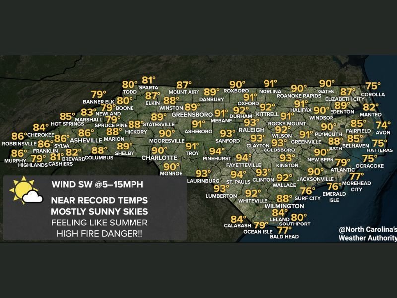
Temperature forecasts for Thursday show a widespread surge of heat blanketing the entire state from the mountains to the coast. Across the western mountains and foothills, highs are expected to range from the upper 70s to mid 80s, with Cherokee reaching 86 degrees, Asheville at 86, and Shelby and Columbus both hitting 89 degrees.
Through the Piedmont region, conditions will be even hotter, with Charlotte reaching 91 degrees, Greensboro hitting 91, Raleigh climbing to 93, and Asheboro matching that mark. Further east across the coastal plain, temperatures will remain elevated with Fayetteville reaching 94 degrees, Pinehurst hitting 94, and Sanford reaching 93 degrees. Even coastal communities will feel the warmth, with Wilmington at 88 and New Bern reaching 90 degrees.
High Wildfire Danger Threatens Much of the State
Thursday’s combination of weather factors has created a particularly dangerous environment for wildfire development and spread across North Carolina. Exceptionally dry fuels left by a prolonged period of below-normal rainfall, combined with low relative humidity values and gusty southwest winds ranging from 5 to 15 mph, means that any fire that ignites could spread rapidly and become difficult to control.
Residents across the state are strongly urged to avoid any outdoor burning on Thursday, including burning of yard debris, trash, or agricultural materials. Even a small spark from equipment, power lines, or discarded cigarettes can trigger a fast-moving wildfire under these conditions. Local burn bans may be in effect in some counties, and residents should check with their county emergency management office before conducting any outdoor activities involving fire or heat-producing equipment.
Mountain Areas Could See a Few Clouds and Showers
While the vast majority of North Carolina will remain dry on Thursday, a weak atmospheric disturbance may produce some clouds and an isolated passing shower across the mountain areas during the evening hours. Forecasters placed the chance of staying completely dry at around 95 percent for most locations, meaning the shower threat is very limited and should not significantly impact the overall picture of a hot, mostly sunny day.
Those in the higher elevations of western North Carolina near Banner Elk, Boone, Newland, and surrounding mountain communities should keep a slight eye on evening sky conditions, though significant rainfall is not expected.
Are you feeling the summer-like heat across North Carolina today or concerned about wildfire conditions in your area? Share your experience and stay informed with the latest coverage at SaludaStandard-Sentinel.com.