Wisconsin and Northern Illinois Brace for Dangerous Overnight Storms as Severe Thunderstorm Watch Covers Southern Wisconsin Until 4 AM Tuesday
WISCONSIN AND ILLINOIS — A Severe Thunderstorm Watch has been issued for southern Wisconsin until 4:00 AM Tuesday in a breaking weather development that is catching the attention of forecasters across the region.
While northern Illinois has not yet been included in the formal watch, meteorologists are warning that things will get significantly noisy across that area during the overnight hours as well. Residents across both states need to have their phones charged and weather radios turned on before going to sleep tonight.
Severe Thunderstorm Watch Covers Southern Wisconsin Until 4 AM
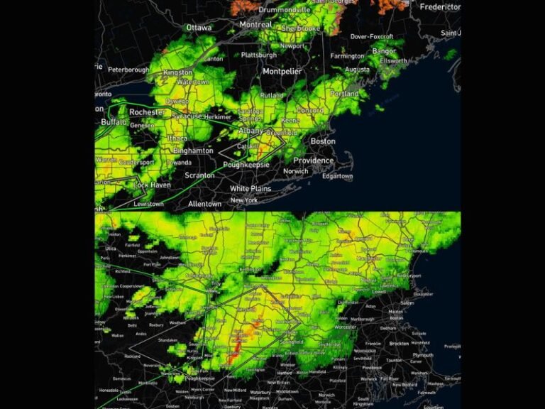
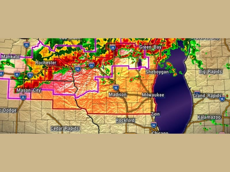
The Severe Thunderstorm Watch now in effect for southern Wisconsin is valid through 4:00 AM Tuesday morning, covering a broad corridor that includes Madison, Milwaukee, Sheboygan, Green Bay, and surrounding communities across the southern tier of the state. Radar at 9:45 PM Monday shows a massive and intense storm complex already pushing across the region with deep red and pink returns indicating extremely heavy precipitation and strong winds within the most intense cells.
Residents across southern Wisconsin who are planning to sleep through the night must keep weather alert notifications active on their phones. Overnight severe thunderstorm events are particularly dangerous because many people are asleep when the most intense conditions arrive and warnings are issued.
Northern Illinois Expected to Get Noisy Overnight
Although northern Illinois has not yet been placed under a formal Severe Thunderstorm Watch as of this update, forecasters are making clear that significant storm activity appears quite likely to impact the area during the overnight hours. Communities across northern Illinois including Rockford, Zion, and areas along the Wisconsin state line are in the path of the approaching storm complex and should prepare accordingly.
The storm system visible on radar is tracking southeast and will continue pushing into northern Illinois through the overnight hours. Do not assume the absence of a formal watch means northern Illinois is safe from impactful weather tonight.
Charge Your Devices and Turn On Weather Radios Right Now
The message from forecasters for both Wisconsin and northern Illinois residents tonight is direct and urgent. Charge your phones completely before going to bed. Turn your NOAA weather radio on and make sure it is programmed for your county. Do not rely solely on outdoor sirens to wake you during overnight severe weather events as they may not be audible from inside a home with windows closed.
Radar shows the storm complex covering a wide area from Eau Claire and Rochester in the northwest through Madison and Milwaukee and extending toward Green Bay and Sheboygan. Every community in this corridor faces the potential for damaging winds and heavy rainfall before 4 AM. Stay alert overnight and follow updates at SaludaStandard-Sentinel.com.