Tornado-Capable Supercell Explodes Over Northeastern Kansas Targeting Missouri River Valley as Dangerous Wind Shear Raises Immediate Threat for Multiple Communities
KANSAS — A rapidly intensifying and potentially tornado-producing supercell is bearing down on northeastern Kansas right now, threatening communities across the Missouri River Valley as forecasters warn that wind shear conditions are fully supportive of tornado development. This is not a drill and not a distant threat. The storm is organized, it is moving, and it is heading directly toward populated areas with every atmospheric ingredient needed to produce a destructive tornado on the ground.
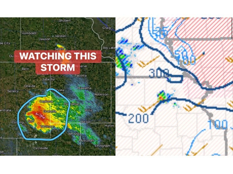
Dangerous Supercell Locked Onto Granada, Capioma and Wetmore
Radar is painting a frightening picture over northeastern Kansas, with the supercell’s most intense core locked directly over Granada, Capioma, Wetmore, and Goff. The storm is showing powerful radar returns with tight rotation indicators concentrated within this cluster of communities, a signature that demands immediate attention from every resident in the surrounding area.
Communities including Sabetha, Hiawatha, Horton, Whiting, Muscotah, and Padonia are dangerously close to this storm’s path and must treat this situation as a life threatening emergency until the threat has passed.
Wind Shear Is Screaming Tornado Potential Right Now
What makes this supercell so alarming is the atmospheric environment surrounding it. Wind shear conditions across northeastern Kansas are not just marginally supportive of tornado development, they are fully loaded and primed for it. The change in wind speed and direction with height across the storm’s environment is providing exactly the rotational energy needed for a violent and long-track tornado to form at any moment.
As the storm now approaches the warm frontal zone over the Missouri River Valley, it is moving into even more favorable territory that could supercharge its tornado potential further. This is the moment when storms like this become most dangerous and most unpredictable.
If You Are in the Path of This Storm Act Now
There is no time to wait and watch from a window. Communities along and near the Missouri River Valley corridor including Falls City, Rulo, Reserve, and Fairview must take this threat seriously right now. Get into your lowest interior room, away from windows, and cover yourself with whatever protection is available.
Mobile home residents and anyone in a vehicle must abandon those locations immediately and find the nearest solid structure. Tornadoes produced by warm frontal supercells can be rain-wrapped and completely invisible until they are seconds away from your location.
Do not rely solely on outdoor sirens. Keep a weather radio or phone alert active and act the moment a tornado warning is issued for your county. Stay alive and stay informed at SaludaStandard-Sentinel.com.