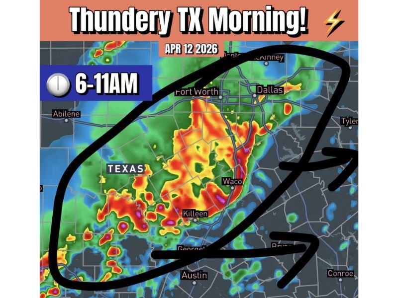
Thundery Morning Ahead for Texas Sunday April 12 as Storm Complex Brings Vivid Lightning and Heavy Rain to Dallas and Austin Between 6 and 11 AM
TEXAS — A complex of storms currently moving through central and north Texas is set to bring a thundery morning to a wide swath of the state this Sunday, April 12, 2026. The storm activity is expected to impact the region between 6 AM and 11 AM, with forecasters noting that the storms should remain sub-severe but will still produce vivid lightning, loud thunder, and much needed rainfall across affected communities including Dallas and Austin.
Storm Complex Moving Through Central and North Texas
The ongoing storm complex is tracking through central and north Texas and will continue to push through the region during the early morning hours of Sunday. The primary timeframe for the heaviest activity runs from 6 AM through 11 AM, covering a broad corridor that includes Fort Worth, Dallas, Waco, Killeen, Georgetown, and Austin.
Radar shows the most intense precipitation cores concentrated between Fort Worth and Waco, with heavy rainfall returns extending south toward the Austin metro. Residents across all of these communities should expect active storm conditions during the morning hours.
Sub-Severe But Still Impactful Conditions Expected
While the storm complex is forecast to remain below severe weather thresholds for most of the affected area, forecasters are emphasizing that conditions will still be highly noticeable and potentially disruptive. Vivid lightning and loud thunder will accompany the heaviest cells as they push through the region, and heavy downpours are expected at times across the Dallas and Austin corridors.
Drivers heading out during the 6 AM to 11 AM window should reduce speeds and increase following distance, as heavy rainfall can lead to reduced visibility and standing water on roadways even with sub-severe storm activity.
Much Needed Rainfall Welcome Across the Region
One silver lining to Sunday morning’s storm activity is that the rainfall will be welcomed across much of central and north Texas, where soil moisture has been below normal heading into spring. The storm complex is expected to deliver meaningful precipitation totals across the affected corridor, providing some drought relief for communities that have been dry in recent weeks.
Despite the welcome rainfall, residents are urged to remain cautious and avoid unnecessary travel during the peak storm window between 6 AM and 11 AM, particularly in areas where lightning activity is most intense.
Once the morning storm complex clears the region, residents should remain weather-aware as additional storm rounds are possible later in the day across parts of Texas. Are you tracking Sunday morning storms in your area? Stay informed and share your reports at SaludaStandard-Sentinel.com.