Ohio Severe Storm Threat Ends With Limited Damage as Cooler Air Arrives Bringing 30 to 40 Degree Temperature Drop
OHIO — A round of storms that moved across parts of the state brought heavy rain, gusty winds, and scattered damage, but the overall severe weather threat ended up being less intense than initially expected.
Storms developed with some strength earlier in the day, producing torrential downpours and isolated damaging wind gusts. However, as they pushed into less favorable atmospheric conditions, the system weakened rapidly.
Storms Lose Strength After Early Development
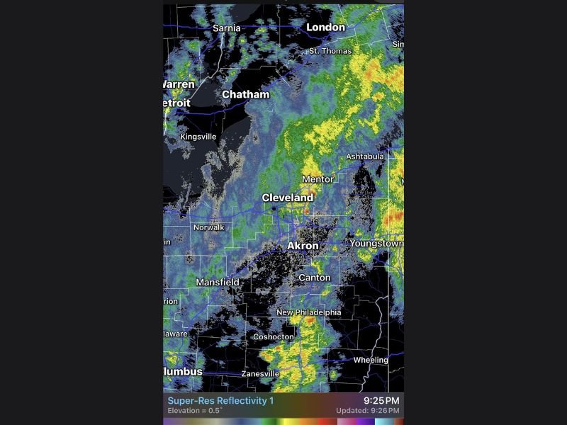
Radar imagery showed storms moving through areas near Cleveland, Akron, and Youngstown, with bands of heavy rain and embedded thunderstorms. While some pockets of stronger weather developed, the storms struggled to maintain intensity.
A key factor in limiting the threat was the arrival of cloud cover earlier than expected, which reduced instability in the atmosphere and prevented storms from fully strengthening.
Damage Reports Limited Despite Initial Concerns
Although there were reports of damage, including downed branches and localized impacts from strong wind gusts, the overall situation did not escalate into a widespread severe weather event.
The setup had the potential to produce more significant impacts, but conditions ultimately did not support a prolonged or more dangerous outbreak.
Event Falls Short of Higher-End Severe Expectations
Forecasters had been monitoring the potential for a more impactful severe weather scenario. However, the storms never fully organized or intensified to the degree initially feared.
This outcome brought some relief, as the event could have taken a much more severe turn if atmospheric conditions had aligned differently.
Major Temperature Drop Set to Follow Storm System
Behind the departing storms, a strong push of cooler air is expected to move into the region. Temperatures are forecast to drop significantly, with readings running 30 to 40 degrees colder compared to earlier conditions.
This sharp cooldown marks a return to more typical early spring conditions, replacing the warmth that helped fuel earlier storm development.
Cooler Conditions Expected Across the Region
As the cooler air settles in, residents across Ohio can expect a noticeable change in the feel of the weather. The shift will bring cooler days and colder mornings following the brief period of stormy conditions.
This transition highlights the rapid swings often seen during the spring season across the Midwest. If you experienced storms or are noticing the sudden temperature drop in your area, share your updates with us at SaludaStandard-Sentinel.com and help others stay informed.