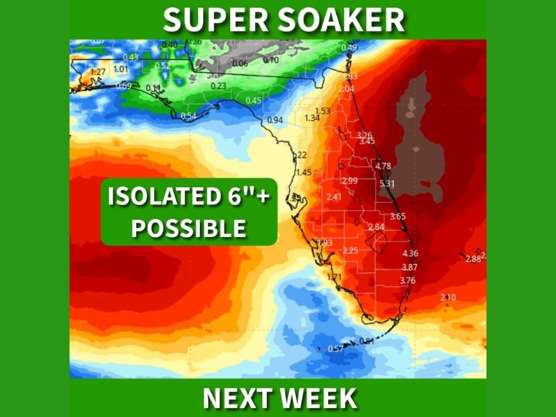
Florida Faces Major Rain Threat Next Week With 2 to 4 Inches Widespread and Over 6 Inches Possible as Front Stalls Across Peninsula
FLORIDA — A prolonged stretch of heavy rain is expected to develop across the state next week as a stalled weather front sets up over the peninsula, raising concerns for flooding and strong coastal winds.
Forecast data shows widespread rainfall totals between 2 to 4 inches across much of Florida, with isolated areas potentially exceeding 6 inches, especially where storms repeatedly move over the same locations.
Stalled Front Sets Stage for Prolonged Rainfall
The main driver behind the upcoming rain event is a slow-moving front expected to stall across Florida. This setup allows moisture to continuously feed into the same areas, increasing the likelihood of extended periods of rainfall.
When fronts stall in this way, rainfall can become persistent and heavy, particularly in central and eastern parts of the state where moisture convergence is strongest.
Flooding Risk Increasing Across the Peninsula
With multiple rounds of rain expected, the threat of flooding is expected to rise throughout the week. Low-lying areas, poor drainage zones, and urban regions could be especially vulnerable if rainfall totals begin to exceed forecast ranges.
The possibility of isolated totals over 6 inches adds additional concern, as localized flooding could develop quickly under heavier storm bands.
Strong Winds Possible Along the East Coast
In addition to heavy rain, a developing area of low pressure east of the Florida Peninsula could enhance wind conditions along the Atlantic coast. Wind gusts between 30 to 40 mph are possible, particularly in coastal communities.
These gusty conditions, combined with heavy rainfall, could lead to difficult travel conditions and minor impacts to infrastructure in exposed areas.
Midweek Could Bring Peak Impacts
The most intense phase of the system is expected to occur around midweek, when the stalled front and developing low pressure system work together to increase rainfall rates and wind speeds.
This period could bring the highest risk for flooding issues across parts of the state, especially if storm activity becomes more organized.
Drought Relief Comes With Trade-Off
While the rain may bring much-needed drought relief to parts of Florida, the rapid accumulation of rainfall in a short period raises the risk of negative impacts.
Heavy rain events like this can quickly shift from beneficial to hazardous, particularly when drainage systems are overwhelmed.
Residents Urged to Prepare for Wet Conditions
Residents across Florida are encouraged to monitor forecasts and prepare for potentially wet and windy conditions throughout the week. Avoiding flooded roadways and staying alert to changing conditions will be key as the system develops.
If heavy rain or flooding impacts your area, share your experience with us at SaludaStandard-Sentinel.com to help keep others informed.