Intense Thunderstorms Slam Pinellas County Florida With Heavy Rainfall Flooding Streets From Clearwater to St. Petersburg Thursday Evening
PINELLAS COUNTY, FLORIDA — Strong thunderstorms moved across the Tampa Bay area Thursday evening, bringing intense rainfall, lightning, and localized flooding concerns, especially across Pinellas County.
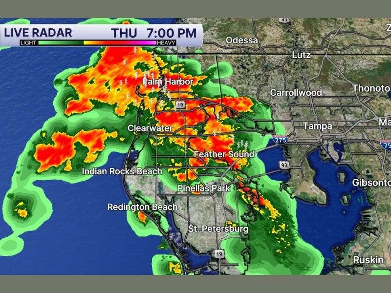
Radar imagery around 7:00 PM shows a concentrated line of heavy storms stretching from Palm Harbor through Clearwater and down toward St. Petersburg, with additional cells pushing inland toward Tampa.
Heavy Rain Bands Soak Clearwater, Palm Harbor, and St. Petersburg
The most intense rainfall is centered over central and northern Pinellas County, including Palm Harbor and Clearwater, where radar indicates persistent heavy downpours.
Further south, St. Petersburg and surrounding communities are also experiencing steady rain, though conditions appear slightly less intense compared to northern zones. These storms are producing widespread rainfall totals that are quickly adding up, raising concerns about street flooding in low-lying and poorly drained areas.
Frequent Lightning and Strong Storm Cores Detected
Radar returns show embedded storm cores with high reflectivity, indicating not just heavy rain but also the potential for frequent lightning and brief gusty winds.
Lightning strikes have been reported throughout the region, particularly along the stronger cells near Clearwater and Feather Sound. While this system is not currently showing signs of severe tornado activity, the intensity of rainfall and electrical activity makes it a dangerous situation for those outdoors.
Storms Pushing Inland Toward Tampa Metro
The storm line is gradually shifting eastward, with rain bands extending toward Tampa and surrounding Hillsborough County areas. As these storms continue to move inland, additional bursts of heavy rain and lightning are expected across the metro region through the evening hours.
Drivers along major roadways, including routes connecting Clearwater and Tampa, may encounter reduced visibility and water accumulation.
Localized Flooding Becoming Primary Concern
With repeated heavy rain falling over the same areas, localized flooding is becoming the primary concern. Urban zones such as Pinellas Park and parts of St. Petersburg are especially vulnerable due to rapid runoff and drainage limitations.
Officials typically advise avoiding flooded roadways during these types of events, as water levels can rise quickly even in short periods of intense rainfall.
Conditions Expected to Gradually Improve Overnight
As the storm system continues eastward, conditions are expected to slowly improve later tonight. However, lingering showers and isolated thunderstorms may persist for several hours before fully clearing out. Residents should continue monitoring weather updates and remain cautious during evening travel as storms move through.
If you’re in the Tampa Bay or Pinellas County area and experiencing heavy rain or flooding, share your conditions and stay updated with more local coverage on SaludaStandard-Sentinel.com.