Alabama Easter Weekend Weather Update Shows Improved Timing With Rain Overnight and Lower Severe Risk Across Western Areas
ALABAMA — A noticeable shift in storm timing is bringing improved conditions for Easter weekend across North and Central Alabama, with rain now expected to move through mainly overnight rather than disrupting the entire holiday.
Forecasters indicate that while wet weather is still expected, it will not be a complete washout, offering better opportunities for outdoor plans, especially later Sunday.
Rain Brings Needed Relief Without Full Weekend Washout
The latest outlook suggests widespread rainfall totals between half an inch to one inch across much of the region. This rainfall is expected to provide much-needed drought relief without overwhelming the weekend.
Importantly, neither Saturday nor Sunday is expected to be a total rainout. Instead, rain will come in waves, allowing for breaks—particularly as conditions begin improving late Sunday.
Storm Timing Shifts Overnight Into Early Sunday
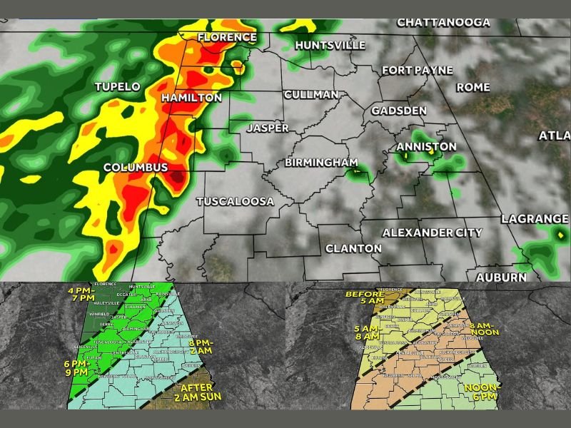
Updated timing shows the main line of rain and storms entering western Alabama Saturday evening, gradually pushing east through the night.
Most areas will see rain between Saturday evening and early Sunday morning, with the heaviest activity clearing out earlier than previously expected. By sunrise Sunday, much of the state will be transitioning out of heavier rain, though some lingering light showers or damp conditions may still be present.
Low Severe Risk Focused in Western Alabama
While the overall setup is not considered a major severe weather event, there is still a low-end risk for a few stronger storms.
This threat is mainly confined to western parts of Alabama, where isolated storms could produce gusty winds or small hail late Saturday into early Sunday. The tornado threat remains very low, with conditions not aligning for a significant tornado outbreak.
Easter Sunday Improves With Sunshine Returning
One of the biggest improvements in the forecast comes for Easter Sunday afternoon. Drier air is expected to move into the region, allowing clouds to break and sunshine to return.
This shift means outdoor activities, family gatherings, and Easter events will have a much better chance of taking place under improving weather conditions.
Morning Services May Still Be Damp but Improving
Early Easter morning services may still contend with leftover moisture or light rain, especially in eastern parts of the state.
However, the improved timing means the risk of heavy downpours during morning hours is lower than earlier projections, offering a more manageable setup for those attending sunrise services.
Overall Outlook Shows Balanced Weekend Conditions
The updated forecast presents a more balanced scenario: beneficial rainfall, limited severe weather concerns, and improving conditions by Sunday afternoon.
This shift highlights how even small timing changes in storm systems can significantly impact holiday plans across the region. Residents are encouraged to stay updated on local conditions, especially Saturday night, when storms are most likely to pass through.
If you’re planning Easter activities this weekend in Alabama, share your plans and stay informed with the latest updates on SaludaStandard-Sentinel.com.