Illinois and Missouri Face Conditional Tornado Threat Thursday Evening as Favorable Setup Builds but Storm Development Remains Uncertain
ILLINOIS, MISSOURI — A potentially volatile weather setup is expected to develop Thursday evening across parts of Illinois and Missouri, where atmospheric conditions could support tornado-producing storms — if storms are able to form.
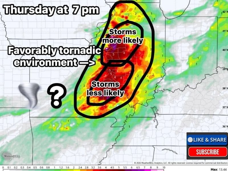
Favorable Tornado Environment Developing Thursday Evening
Forecast data shows that a strongly supportive environment for tornadoes will be in place across the western half of the region by Thursday evening. This includes key ingredients such as instability, wind shear, and moisture — all necessary for severe storm development.
The most favorable zone stretches across portions of western Illinois into eastern Missouri, where conditions could allow storms to rotate and potentially produce tornadoes.
Storm Development Remains the Biggest Question
Despite the favorable setup, one major uncertainty remains: whether storms will actually develop.
Forecasters note that while the environment may be primed for severe weather, storm initiation is not guaranteed. If storms fail to form, the region could see little to no severe weather despite the strong atmospheric setup.
However, if even a single storm is able to develop within this environment, it could quickly become severe and pose a tornado risk.
Higher Storm Chances North Toward Illinois
Current projections suggest that storm development is more likely in areas farther north, particularly toward parts of Illinois, including regions near and north of Galesburg.
This means northern sections of the risk area may have a better chance of seeing storms, while southern areas could remain quieter — though still within the favorable environment.
Evening Timeline Key for Severe Risk
The window of concern is centered around the evening hours, with conditions expected to peak near or after sunset. This timing increases concern, as severe weather occurring later in the day can be more difficult to track and respond to.
Residents should remain alert during the evening period, especially as forecast details become clearer closer to the event.
“Conditional Risk” Scenario Explained
This setup is best described as a conditional severe weather event. The atmosphere has all the necessary ingredients for tornadoes, but without storm development, the threat will not materialize.
This type of setup can be particularly challenging, as outcomes can range from quiet conditions to isolated but intense severe storms.
Residents Urged to Stay Prepared Despite Uncertainty
Even with uncertainty in storm development, residents across Illinois and Missouri are encouraged to stay weather-aware and have a plan in place.
Having multiple ways to receive warnings and understanding where to seek shelter remains critical, especially during spring severe weather season. Conditions will continue to be monitored closely, and updates are expected as confidence in storm development increases.
Have thoughts on this setup or preparing for Thursday’s potential storms? Share your perspective and stay updated with ongoing coverage at SaludaStandard-Sentinel.com.