Massachusetts and Connecticut Under Severe Thunderstorm Watch as Snow North and Heavy Rain South Split New England Overnight
MASSACHUSETTS, CONNECTICUT — A complex and dynamic weather system is moving across New England tonight, bringing a sharp divide between snow in northern areas and heavy rain with storm threats farther south, including a severe thunderstorm watch for parts of western Massachusetts and northwestern Connecticut.
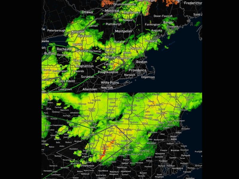
Storm System Splits Region Into Two Weather Zones
Radar imagery late this evening shows a clear split across the region, with colder air supporting snowfall across northern New England while warmer air fuels widespread rain across southern areas.
Northern sections of states like Vermont, New Hampshire, and Maine are seeing snow and mixed precipitation, particularly closer to the Canadian border. Meanwhile, much of Massachusetts and Connecticut remain firmly in the rain zone.
Severe Thunderstorm Watch Targets Western Massachusetts and Northwestern Connecticut
The most concerning part of the system is focused across western Massachusetts and northwestern Connecticut, where a severe thunderstorm watch has been issued.
Storms moving through this region are capable of producing strong wind gusts and localized downpours. Embedded heavier cells within the rain shield could briefly intensify, increasing the risk of isolated severe conditions overnight.
Communities near the Massachusetts–New York border and into northern Connecticut are especially at risk as the system continues to track eastward.
Heavy Rain Expands Across Southern New England
Across much of southern New England, steady to heavy rain is dominating the overnight forecast. Areas including Albany, Springfield, Hartford, and extending toward Boston are experiencing widespread rainfall, with occasional heavier bursts visible on radar. This persistent rain could lead to localized ponding on roads and reduced visibility for overnight travel.
Snow Continues Across Northern Areas
Farther north, colder temperatures are allowing precipitation to fall as snow. Areas in northern New York, Vermont, New Hampshire, and Maine are seeing accumulating snowfall, particularly in elevated terrain. This sharp contrast between snow and rain highlights the strength of the temperature gradient across the region.
Overnight Impacts and Travel Concerns
The combination of heavy rain in the south and snow in the north is expected to create challenging travel conditions across multiple states overnight.
Drivers in southern areas should be cautious of slick roads and reduced visibility, while those in northern zones may encounter snow-covered roadways and changing conditions.
System Gradually Moves East by Morning
The storm system will continue pushing eastward overnight, gradually exiting the region by early morning. Conditions are expected to improve from west to east, though lingering showers may persist into the early hours.
Residents across Massachusetts and Connecticut are urged to remain alert for changing conditions, especially in areas under the severe thunderstorm watch. Have you seen heavy rain or snow in your area tonight? Share your updates and stay connected with ongoing coverage at SaludaStandard-Sentinel.com.