Illinois and Wisconsin Face Midweek Cold Blast, Thursday Storm Threat and Late Week Rain Shift Before Cooler Easter Weekend
NORTHERN ILLINOIS, SOUTHERN WISCONSIN — A complex stretch of spring weather is setting up across the region this week, bringing a sharp mix of cold winds, a potential severe storm window, and another round of rain before temperatures cool again heading into Easter weekend.
Wednesday Brings Cold Winds and Chilly Conditions
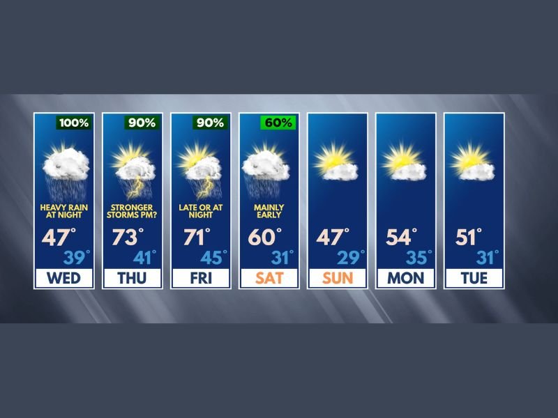
Wednesday will feel more like late winter than early spring across northern Illinois and southern Wisconsin. While much of the daytime is expected to remain dry, conditions will be dominated by strong winds and unseasonably cold air.
High temperatures may reach the upper 40s, but persistent wind will keep wind chills locked in the 30s for most of the day. By evening, conditions shift again as a cold, wind-driven rain develops after sunset and continues overnight.
Thursday Turns Warmer but Storm Threat Increases
A dramatic change arrives Thursday as winds shift out of the south, pulling warmer air into the region. Temperatures are expected to surge into the lower 70s, but this warmth comes with increasing instability.
Forecasters are closely watching a developing storm window between 12 PM and 8 PM, when conditions could support stronger storms. Gusty winds will already be in place, and any breaks in cloud cover could further enhance storm development.
While the exact severity is still uncertain, this period is being flagged as a “heads up” timeframe for potentially noisy weather, including thunderstorms capable of heavy rain and gusty winds.
Friday Stays Mild Before Another System Moves In
Friday begins on a quieter note, with dry and pleasant conditions likely through much of the day. Temperatures are expected to remain mild, briefly holding in the 70s across parts of the region.
However, another strong cold front is expected to arrive late in the day or during the evening hours. This system will bring renewed chances for showers and thunderstorms, along with periods of heavier rainfall overnight. While it is too early to determine the full severity potential, this late-week system will be closely monitored.
Saturday Brings Lingering Showers and Cooler Air
Showers and a few storms may linger into early Saturday, especially during the morning hours. As the system moves out, cooler and drier air will begin to settle back into the region.
Afternoon conditions are expected to improve, but temperatures will drop noticeably compared to the warmth of Thursday and Friday.
Easter Sunday Looks Quiet but Cool
Looking ahead to Sunday, Easter is expected to remain mostly quiet across both Illinois and Wisconsin. However, temperatures will trend cooler than typical early April averages. Dry conditions should dominate, offering a calmer end to a week filled with shifting weather patterns.
Next Week Starts Seasonable After Wild Swings
Early next week is expected to bring more stable and seasonable conditions, with temperatures gradually returning closer to normal for this time of year.
After a week of sharp swings between cold, warmth, storms, and rain, the region will finally begin to settle into a more typical spring pattern.
Residents across Illinois and Wisconsin can share how these rapid weather changes are impacting their plans by visiting SaludaStandard-Sentinel.com.