North Carolina, South Carolina and Georgia See Light Rain While Tennessee and Western Carolinas Pick Up Higher Totals Over Next 7 Days
SOUTH CAROLINA — A gradual shift toward a wetter weather pattern is expected across the Southeast over the next seven days, though rainfall totals will vary significantly depending on location.
Forecast data shows the heaviest rainfall remaining west of the Carolinas, while parts of North Carolina, South Carolina, and Georgia are expected to receive lighter but still beneficial precipitation.
Western Areas See Heavier Rainfall Totals
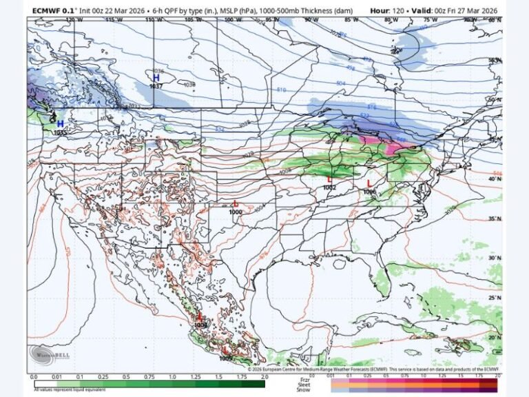
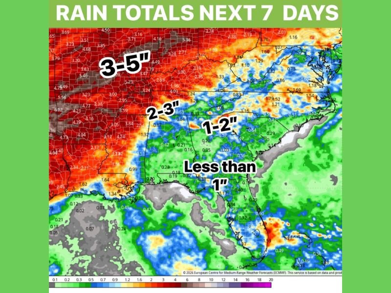
The highest rainfall totals are expected to stay west of the Carolinas, particularly across parts of Tennessee and areas farther into the Mississippi Valley.
Some locations in these regions could receive between 3 to 5 inches of rain over the next week, with a broader zone of 2 to 3 inches extending eastward toward the western portions of North Carolina. This heavier rainfall could provide meaningful moisture to areas that have been dealing with dry conditions.
Western North Carolina Could See 1 to 2 Inches
Across western North Carolina, rainfall totals are expected to range between 1 and 2 inches, especially in the mountains and foothill regions.
These areas will be closer to the main storm track, allowing for more consistent rainfall compared to locations farther east. While not excessive, these totals could help improve soil moisture and support early spring growth.
South Carolina and Georgia Expect Lighter Rainfall
Further south and east, including much of South Carolina and Georgia, rainfall amounts are expected to be lighter, generally staying under 1 inch for the week.
While this may not significantly impact drought conditions, it still represents a shift toward more active weather compared to recent dry periods. Scattered showers are expected to occur at times, particularly between Wednesday and Friday.
Multiple Rain Chances Through Midweek
Rather than a single storm event, the pattern will feature several opportunities for rain over the next seven days.
Most of the precipitation is expected to occur in waves, with the best chances arriving during the midweek period. This staggered approach increases the likelihood that at least some rainfall will reach most areas. However, totals will depend on how each system tracks and develops.
Gradual Shift Toward Wetter Pattern
While this setup is not expected to completely eliminate dry conditions, it does signal a move toward a more active weather pattern across the Southeast.
Meteorologists suggest that continued storm activity beyond this period could further increase rainfall totals, especially if the pattern remains consistent into early April. For now, the upcoming week offers at least some relief and multiple chances for measurable rainfall.
Are you seeing rain in your area or still waiting for more consistent showers? Share your local conditions and stay updated with the latest forecasts at SaludaStandard-Sentinel.com.