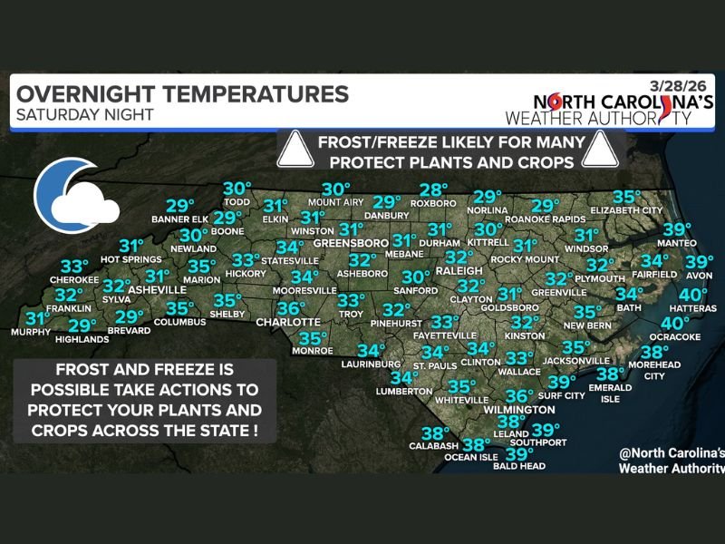
North Carolina Temperatures Drop Into 20s and Low 30s Overnight Bringing Frost and Freeze Risk Across Charlotte, Raleigh, Greensboro and Mountain Areas
NORTH CAROLINA — A widespread drop in overnight temperatures is expected across the state Saturday night, with many areas falling into the upper 20s and low 30s, creating a strong risk for frost and light freeze conditions.
Forecasters warn that these colder temperatures could impact early spring vegetation, especially as many plants and crops have already begun growing during recent warmer weather.
Temperatures Falling Into Freeze Range Across Interior Regions
Forecast data shows much of inland North Carolina, including cities like Greensboro, Winston-Salem, Raleigh, and Durham, dropping to around 30 to 32 degrees overnight.
Mountain regions are expected to see even colder conditions, with some locations dipping into the upper 20s. Areas such as Boone, Banner Elk, and surrounding higher elevations could experience the coldest temperatures statewide. These conditions are cold enough to trigger frost formation and potentially damage sensitive plants.
Charlotte and Central Areas Also Near Freezing
Across the Charlotte metro and surrounding counties, overnight lows are expected to fall into the mid-30s, with some localized areas potentially reaching near-freezing conditions.
While urban areas may stay slightly warmer, outlying and rural locations could see temperatures dip low enough for patchy frost to develop.
Communities across central North Carolina, including Asheboro, Sanford, and Troy, are also expected to experience similar conditions.
Coastal Areas Stay Slightly Warmer but Still Chilly
Along the coast, temperatures are forecast to remain somewhat milder, generally ranging from the mid-30s to near 40 degrees.
Cities such as Wilmington, Jacksonville, and the Outer Banks will likely avoid widespread freezing temperatures, but the cool air will still create a chilly overnight environment. Despite the warmer readings, sensitive vegetation in these areas could still be affected by cooler-than-normal conditions.
Frost and Freeze Threat Could Impact Plants and Crops
The biggest concern with this cold snap is its potential impact on agriculture and home gardens. With the growing season already underway in parts of the state, plants are especially vulnerable to sudden drops in temperature.
Frost can form when surface temperatures fall to freezing, even if air temperatures remain slightly above 32 degrees. This can damage leaves, flowers, and early crops. Residents are encouraged to take protective measures, such as covering plants or bringing potted vegetation indoors.
Clear Skies and Calm Winds Contributing to Cooling
The rapid temperature drop is being driven by clear skies and relatively calm conditions, which allow heat to escape quickly from the ground overnight.
This process, known as radiational cooling, is common during spring and often leads to sharp overnight temperature declines following mild daytime conditions. The result is a classic setup for widespread frost across inland areas.
Conditions Expected to Improve After Sunrise
Temperatures are expected to rebound after sunrise Sunday, reducing the frost threat as the day progresses. However, the early morning hours will remain the most critical period for plant protection.
Residents are advised to monitor local conditions and take precautions before temperatures reach their lowest point overnight. Have you already started planting this season, or are you preparing for the cold snap? Share your experience and stay updated with the latest weather alerts at SaludaStandard-Sentinel.com.