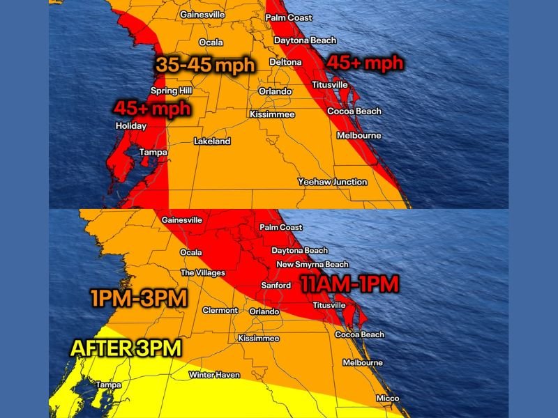
Florida Braces for Strong Wind Surge Saturday as Cold Front Brings 45+ MPH Gusts From Tampa to Daytona Beach and Orlando
FLORIDA — A fast-moving cold front is expected to sweep across central Florida on Saturday, bringing a sharp increase in wind speeds, cloudy skies, and scattered rain showers by the evening hours.
Forecasters warn that wind gusts could reach or exceed 45 mph in some areas, especially along the coast, creating potentially hazardous conditions throughout the afternoon and evening.
Strongest Wind Gusts Expected Along Coastal Areas
The highest wind gust potential is forecast along Florida’s east and west coasts, where speeds could exceed 45 mph. Areas including Daytona Beach, Titusville, and Cocoa Beach on the Atlantic side, along with Tampa and surrounding Gulf Coast communities, are expected to experience the strongest impacts.
Inland locations such as Orlando, Ocala, and Lakeland are also likely to see gusts in the 35 to 45 mph range. While slightly lower than coastal areas, these winds can still cause disruptions, particularly with loose outdoor objects and travel.
Timing of Wind Arrival Across Central Florida
The onset of strong winds will vary depending on location, with coastal regions seeing the earliest impacts.
Communities along the eastern coastline, including areas near Daytona Beach and Titusville, could begin experiencing strong winds as early as late morning, between 11 AM and 1 PM. As the system pushes inland, cities like Orlando and surrounding areas will see increasing winds during the early afternoon hours.
Further west toward Tampa and the Gulf Coast, the strongest winds are expected later in the day, generally between 1 PM and 3 PM, with some areas not seeing peak conditions until after 3 PM.
Cold Front Brings Clouds and Spotty Rain Showers
Along with the gusty winds, the advancing cold front will bring increasing cloud cover across the region. By evening, skies are expected to become fully overcast, with scattered rain showers developing in some areas.
Rainfall is not expected to be widespread or heavy, but brief showers could accompany the frontal passage, adding to the unsettled weather conditions. The front will also introduce a noticeable drop in temperatures, bringing a cooler feel compared to recent days.
Potential Impacts From Gusty Conditions
Wind gusts in the 35 to 45+ mph range can create a variety of impacts, including downed tree branches, minor power disruptions, and difficult driving conditions, especially for high-profile vehicles.
Beach areas may also experience rough surf and blowing sand, reducing visibility in some spots. Residents are advised to secure loose outdoor items and exercise caution while traveling during peak wind periods. Even outside of the strongest zones, gusty winds can still pose a risk, particularly during the transition period as the front moves through.
Rapid Weather Shift Highlights Active Pattern
This system is another example of how quickly weather conditions can change during the spring season. A relatively calm start to the day will give way to much more active conditions within a matter of hours.
As the cold front exits the region later Saturday night, conditions are expected to gradually improve, though cooler air will linger behind it. Residents are encouraged to stay updated on local forecasts and be prepared for changing conditions throughout the day.
Have you experienced strong winds or sudden weather changes in your area recently? Share your experience and stay connected with the latest updates at SaludaStandard-Sentinel.com.