Ohio, Indiana and Pennsylvania Face 6 PM to 10 PM Severe Storm Line With Large Hail, 70 MPH Winds and Intense Lightning Threat
OHIO — A dangerous line of severe storms is expected to sweep across parts of Ohio, Indiana, and Pennsylvania Thursday evening, with forecasters pinpointing a critical window between 6 PM and 10 PM for the most intense activity.
High-resolution weather models are aligning on this timeframe, indicating a fast-moving and potentially damaging storm system capable of producing large hail, strong wind gusts, and widespread lightning.
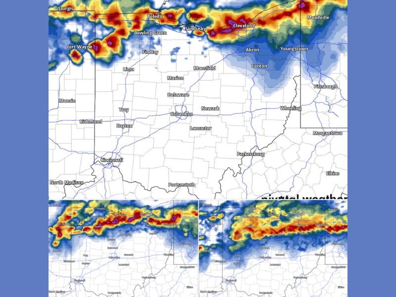
Storm Line Expected to Intensify Across Northern Ohio Corridor
The strongest storms are projected to track across northern sections of Ohio, including areas near Toledo, Sandusky, Cleveland, and Youngstown. This corridor appears to be directly in the path of the most organized and intense part of the storm line.
Communities along this route could experience rapidly deteriorating conditions as storms develop and move eastward. The setup suggests a well-defined line capable of maintaining strength as it crosses state lines into Pennsylvania. The alignment of storms along this northern belt increases the likelihood of consistent impacts across multiple cities rather than isolated cells.
Large Hail and Damaging Winds Pose Primary Threats
The developing storm line is expected to bring strong updrafts capable of producing large hail cores. These hailstones could cause damage to vehicles, roofs, and outdoor property.
In addition, wind gusts are forecast to reach around 70 mph, with the possibility of even stronger gusts in localized areas. Winds at this strength can down trees, damage power lines, and lead to scattered outages. The combination of hail and wind makes this system particularly dangerous, especially for those outdoors or traveling during the evening hours.
Lightning Activity Expected to Be Widespread and Intense
Another major concern with this storm system is the expected level of electrical activity. Forecast models indicate a significant surge in lightning, with storms capable of producing near-constant flashes.
This type of lightning activity not only creates hazardous outdoor conditions but can also lead to power disruptions and reduced visibility during heavy rain. Residents are advised to take lightning safety seriously, as this storm system could produce frequent strikes over a wide area.
Fast-Moving Storms Could Catch Residents Off Guard
One of the key factors in this event is the speed of the storm line. Fast-moving systems can quickly shift from calm conditions to severe weather within minutes, leaving little time to react.
Areas that may appear quiet earlier in the day could see a rapid escalation in storm intensity during the evening window. This makes it critical for residents to stay weather-aware and prepared for sudden changes. Travel during this period may become hazardous, especially along major routes connecting cities across Ohio, Indiana, and Pennsylvania.
Evening Timing Increases Risk for Commuters and Residents
The 6 PM to 10 PM timing places the most dangerous conditions during peak evening hours, when many people are commuting or engaged in outdoor activities.
This overlap increases the potential for disruptions, including traffic delays, accidents, and power outages. Residents are encouraged to plan ahead and consider adjusting schedules if severe weather approaches.
Preparedness and awareness will be key in reducing risks associated with this system. If you’re in Ohio, Indiana, or Pennsylvania, share what conditions look like in your area and help keep others informed by visiting SaludaStandard-Sentinel.com.