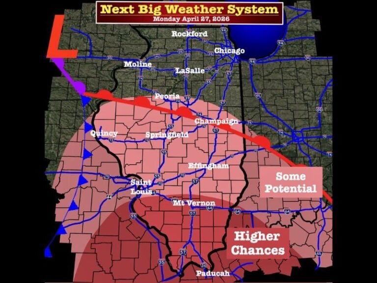
Michigan, Indiana and Ohio Could See Late Week System With Rain South and Snow Risk in Northern Areas While Most of Midwest Stays Quiet
UNITED STATES — A relatively quiet weather pattern is expected across much of the Midwest this week, but forecasters are closely watching a late-week system that could bring a mix of rain and snow to parts of Michigan, Indiana, and Ohio.
Current model guidance suggests that while no major severe or winter storms are anticipated, a developing disturbance around Thursday into Friday could introduce pockets of precipitation across the region.
Mostly Calm Conditions Through Midweek
For much of the week, conditions across the Midwest are expected to remain stable, with no widespread severe weather or major winter systems.
High pressure dominating the region is helping to keep skies relatively clear and precipitation limited, allowing for a quieter stretch compared to recent active patterns.
This calm setup, however, begins to shift toward the end of the week.
Late Week System Begins to Take Shape
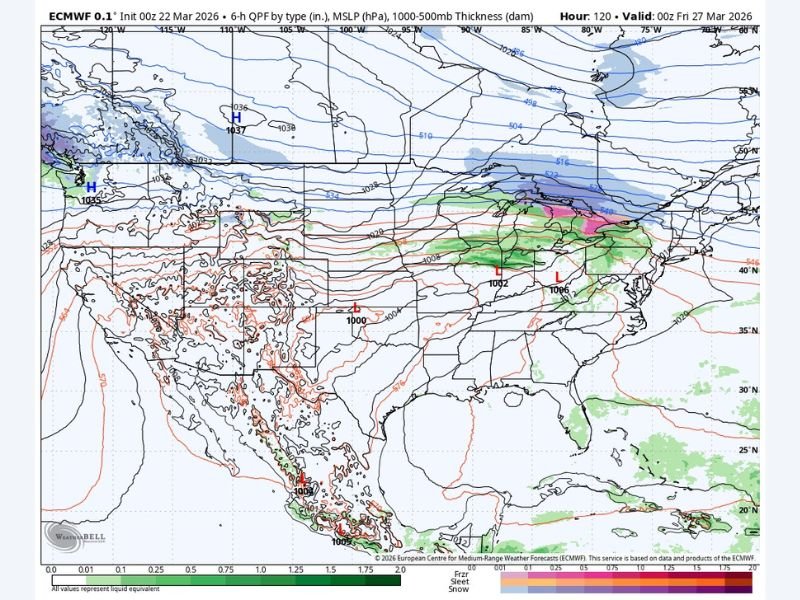
Forecast models indicate a developing low-pressure system that may track across the central United States and into the Great Lakes region by Thursday into Friday.
The majority of moisture and instability associated with this system is expected to remain south of Michigan, particularly impacting areas across Indiana and Ohio with light to moderate rainfall.
Snow Possible in Northern Michigan
While southern portions of the region will likely see rain, colder air lingering in northern Michigan could allow for a transition to snow.
Model projections show the potential for light snowfall across northern parts of the state, especially in areas closer to the Upper Peninsula and northern Lower Michigan.
At this stage, snowfall amounts and exact placement remain uncertain, but the signal for at least some wintry precipitation is present.
Why Most of the Region Avoids Major Impacts
One key factor limiting the severity of this system is its projected track.
By keeping the strongest dynamics and moisture south of Michigan, the setup reduces the likelihood of widespread severe weather or significant winter accumulation.
Instead, impacts appear more scattered and localized, with varying conditions depending on location.
What to Watch Moving Forward
Forecasters emphasize that this system is still developing, and small shifts in its path could change precipitation types and coverage areas.
Residents in northern Michigan should monitor updates for potential snow chances, while those further south may want to prepare for periods of rain later in the week.
Even though this is not expected to be a major event, it serves as a reminder of how quickly spring weather can shift across the Midwest.
If you’re seeing changes in weather conditions in your area, share your experience and follow ongoing updates on SaludaStandard-Sentinel.com.