Ohio Miami Valley and Surrounding Areas Face Sunday Severe Storm Risk With Large Hail Primary Threat and Evening Storm Window
OHIO — A developing weather setup is bringing a low-end but closely monitored severe storm threat to parts of Ohio on Sunday, particularly across the Miami Valley region.
Forecasters say storms are expected to develop behind a cold front during the afternoon and evening hours, with the greatest concern focused on large hail and isolated strong storms.
Storm Risk Focused Across Miami Valley Region
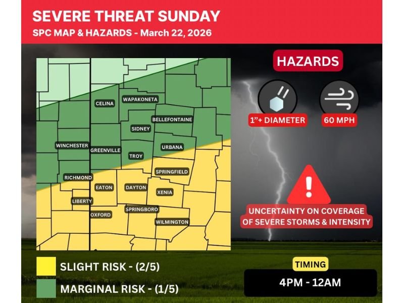
The latest outlook places parts of western and central Ohio, including cities like Dayton, Springfield, and Xenia, in a Level 1 (Marginal) to Level 2 (Slight) risk zone for severe weather.
This setup suggests isolated to scattered severe storms are possible, but not everyone in the region will see impacts. Some areas may experience little to no storm activity at all.
The risk zone has shifted slightly south in recent updates, placing more emphasis on areas along and just south of the Miami Valley.
Large Hail Expected to Be Primary Hazard
The biggest concern with Sunday’s storms is the potential for large hail, with some storms capable of producing hailstones around 1 inch in diameter or larger.
Damaging winds up to around 60 mph are also possible but are considered a secondary threat compared to hail.
At this time, the environment does not appear highly favorable for tornado development, reducing the risk of more widespread severe impacts.
Storm Timing Set for Late Afternoon Into Night
Storms are expected to begin developing during the late afternoon, with the main window for activity stretching from around 4 PM through midnight.
This timing means storms could impact both evening travel and nighttime conditions, making it important for residents to stay aware of changing weather. The progression of storms will generally move south-southeast through the region as the system evolves.
Uncertainty Remains Key Factor in Forecast
One of the most important aspects of this forecast is uncertainty. The storm setup is somewhat unusual, with elevated instability developing behind the cold front rather than ahead of it.
If storms remain limited behind the front, impacts could stay isolated. However, if storms manage to develop earlier or break through atmospheric limitations, they could become more organized and stronger.
Forecasters stress that confidence in exact storm coverage and intensity remains moderate, and updates will continue as new data becomes available.
Residents Urged to Monitor Conditions and Stay Prepared
Officials recommend a “wait and monitor” approach for now, as the situation continues to evolve throughout the day. Residents should ensure they have multiple ways to receive weather alerts and be ready to take shelter if severe weather warnings are issued. Even though the overall risk is not extreme, isolated storms can still produce sudden and impactful conditions.
If you’re in Ohio or surrounding areas and notice changing weather conditions, share your updates with us. Stay connected with SaludaStandard-Sentinel.com for the latest severe weather coverage and real-time alerts.