Illinois, Missouri, and Indiana Face Unstable Sunday Storm Setup as Cold Front Triggers Energy Surge from St. Louis to Chicago
ILLINOIS — A developing weather pattern is drawing attention across Illinois, Missouri, and Indiana as a strong cold front moves south on Sunday, bringing a potentially unstable setup from St. Louis to Chicago.
Forecasters indicate a notable increase in storm energy across southern Illinois and nearby regions, raising concerns about how conditions could evolve if key atmospheric barriers weaken.
Storm Energy Builds Across Southern Illinois and Missouri
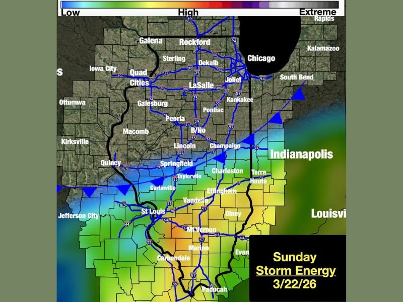
The latest guidance shows a significant presence of CAPE, or storm energy, concentrated across southern parts of Illinois and extending into eastern Missouri and western Indiana. This energy is a critical ingredient for storm development, especially when paired with strong wind shear and lift.
Meteorologists note that shear and lift will be sufficient across the region, meaning storms could organize if they are able to develop. Low-level moisture is also expected to be present, further supporting the potential for storm activity near cities like St. Louis, Carbondale, and Effingham. However, despite the favorable ingredients, the setup is not straightforward.
Dry Air and Atmospheric Cap Could Limit Storm Development
One of the main uncertainties in this forecast is the presence of dry air in the mid-levels of the atmosphere, along with a strong cap. This cap acts like a lid, preventing storms from forming even when energy is available.
If the cap holds, storm activity could remain limited despite the high energy levels. But if the cap weakens or breaks as the cold front pushes south, storms could develop rapidly and potentially intensify.
Forecasters are closely monitoring whether mid-level moisture increases enough to overcome this cap. Even small changes in this balance could significantly alter the outcome.
Sharp Temperature Contrast Adds to Instability
Another striking feature of this system is the dramatic temperature difference across Illinois. Forecasts suggest temperatures could reach the upper 80s near St. Louis, while areas around Chicago may remain in the upper 30s.
This nearly 50-degree contrast across the state highlights the strength of the frontal boundary and adds to the overall instability in the atmosphere. Such sharp gradients often play a role in enhancing storm development when combined with available energy and moisture.
This temperature divide could also influence where storms are most likely to form, with southern and central Illinois appearing to be the most favorable zones.
Areas to Watch from St. Louis to Indianapolis Corridor
The highest storm energy currently appears to be centered from the St. Louis metro area into southern Illinois and stretching toward parts of Indiana, including areas near Indianapolis.
Cities such as Marion, Mount Vernon, and Vandalia fall within zones showing elevated energy levels. If storms do develop, these regions could see the strongest activity. Meanwhile, northern Illinois, including Chicago, may remain on the cooler side of the system, reducing storm potential but still experiencing the effects of the advancing front.
Uncertain but Closely Watched System Heading into Sunday
At this stage, forecasters emphasize that the setup remains conditional. The ingredients for storms are present, but key limiting factors could prevent widespread development.
The situation could change quickly depending on how the atmosphere evolves as the cold front moves through. This makes it an important system to monitor closely through the weekend.
Residents across Illinois, Missouri, and Indiana are encouraged to stay aware of updates as Sunday approaches, especially in southern areas where conditions appear most favorable for storm development.
For ongoing updates and detailed regional coverage, readers can follow the latest reports on SaludaStandard-Sentinel.com and share what conditions are like in their area as this system unfolds.