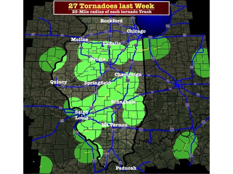
Illinois and Missouri Tornado Outbreak Map Shows 27 Twisters Verified Within 25 Miles of Communities Across Chicago, Springfield, Peoria and St. Louis
ILLINOIS, MISSOURI — A newly released analysis map is shedding light on just how widespread last week’s tornado outbreak truly was, showing that at least 27 tornadoes tracked across large portions of Illinois and parts of Missouri, with many communities falling within just a 25-mile radius of these dangerous paths.
The visualization challenges a growing perception that the severe weather event was a “bust,” instead highlighting how accurately the forecasts captured real-world impacts.
27 Tornado Tracks Covered Major Population Corridors
The map outlines a 25-mile radius around each confirmed tornado track, revealing broad coverage across key cities and transportation corridors.
In Illinois, impacted areas include Chicago, Rockford, LaSalle, Peoria, Springfield, Champaign, Effingham, and Mt. Vernon. The tornado influence zone also extends into eastern Missouri, including the St. Louis metro area, and stretches toward western Kentucky near Paducah.
This means that even if a tornado did not directly strike a specific neighborhood, it may have still passed dangerously close.
Forecast Probabilities Matched Real-World Impacts
According to forecast data from last week, the probability of tornadoes ranged between 15–29% across north-central Illinois and 10–14% across southern parts of the state.
While those numbers may sound modest at first glance, meteorologists emphasize that they translate to a significant real-world risk — roughly a 1 in 5 to 1 in 4 chance of a tornado occurring within 25 miles of a given location.
When compared to the typical daily tornado probability of around 1 in 1,000, last week’s setup represented a major escalation in severe weather potential.
Why Some Residents Thought It Was a “Bust”
Despite the widespread tornado activity, many residents felt the event underperformed — largely because their specific location may not have been directly hit.
However, experts stress that severe weather forecasts are not designed to guarantee impact at a single point, but rather to highlight regions where conditions are favorable for tornado development. The 25-mile radius shown on the map illustrates just how localized tornado paths can be, even during widespread outbreaks.
Map Highlights How Close Communities Really Were
The data shows that numerous communities were within close proximity to tornado tracks — in some cases, multiple tornadoes occurred near the same general area.
Given that Illinois alone spans roughly 57,900 square miles, a 25-mile radius is relatively small, yet the clustering of these zones demonstrates how active and concentrated the outbreak was.
For cities like Springfield, Peoria, and Champaign, the map suggests repeated nearby activity rather than isolated incidents.
A Reminder of Forecast Accuracy and Real Risk
Meteorologists say this event serves as a clear example of how modern forecasting continues to improve, even when public perception doesn’t always align with the outcome.
The fact that multiple tornadoes occurred within forecasted zones — and within relatively close distances to populated areas — reinforces that the severe weather outlook was not only justified but verified.
At the same time, the event also serves as a sobering reminder: while some communities avoided direct impact, others are still dealing with damage and recovery.
Looking Ahead
As storm season continues to ramp up across the central United States, experts urge residents to take forecast probabilities seriously — even when the risk may not seem extreme at first glance.
Understanding how these outlooks work can make a critical difference in preparedness and response when severe weather strikes. Stay with Saluda Standard-Sentinel for continued updates on severe weather patterns and analysis across the United States.