Kentucky and Indiana Under Tornado Watch Until 3 AM Monday as Louisville, Indianapolis and Multiple Cities Face 80 MPH Wind Threat
KENTUCKY AND INDIANA — A Tornado Watch has been issued across large portions of Kentucky and Indiana, placing several major cities — including Louisville and Indianapolis — under heightened alert for severe storms capable of producing tornadoes and damaging winds overnight.
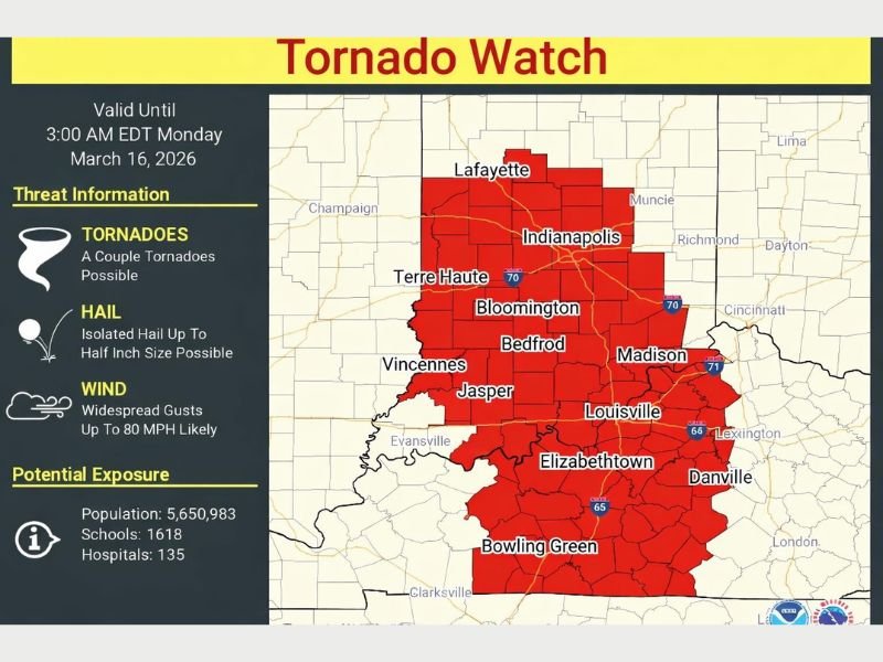
The watch remains in effect until 3:00 AM EDT Monday, March 16, 2026, as a powerful storm system pushes through the region.
Meteorologists say the storms could bring isolated tornadoes, strong wind gusts reaching up to 80 miles per hour, and pockets of hail as the system moves across the Ohio Valley.
Louisville and Indianapolis Among Cities Under Tornado Watch
The watch includes a wide swath of communities across both states. Among the cities specifically mentioned within the watch area are Louisville, Elizabethtown, Danville, Bowling Green, Frankfort, Liberty, Versailles and Owenton in Kentucky.
In neighboring Indiana, areas including Indianapolis, Lafayette, Bloomington, Bedford, Madison, Terre Haute, Vincennes and Jasper are also inside the watch zone.
This places millions of residents within the potential impact area for severe weather during the overnight hours.
Damaging Winds Could Reach 80 MPH
Forecasters warn that widespread damaging wind gusts may be the biggest concern, with some storms capable of producing winds up to 80 miles per hour.
Winds of that strength can easily down trees, damage roofs, and knock out power lines, leading to scattered power outages across affected communities.
Emergency officials warn that even storms without tornadoes may still produce dangerous straight-line winds.
Isolated Tornadoes and Hail Also Possible
While damaging winds are expected to be the primary hazard, meteorologists say a couple of tornadoes cannot be ruled out within the watch area.
Storms developing within a line of thunderstorms could spin up brief tornadoes as the system moves through Kentucky and Indiana.
The storms may also produce isolated hail up to half an inch in diameter, which could accompany the stronger cells.
Millions of Residents Within the Watch Area
According to estimates associated with the watch area, more than 5.6 million people live within the region currently under the tornado watch.
The impacted area also includes approximately 1,618 schools and 135 hospitals, highlighting the potential scale of the severe weather risk.
Because the watch covers such a large portion of both states, emergency officials are urging residents to remain alert throughout the night.
Overnight Storms Could Develop Quickly
Severe weather overnight can be particularly dangerous because people are often asleep when warnings are issued.
Meteorologists encourage residents to ensure they have multiple ways to receive weather alerts, including smartphone notifications or weather radios that can wake them if a tornado warning is issued.
Storms moving through the region may strengthen quickly, meaning warnings could be issued with little advance notice.
Residents Urged to Stay Weather Aware
With the tornado watch lasting through the early morning hours, residents across Kentucky and Indiana are encouraged to stay alert and monitor local weather updates.
Officials recommend identifying a safe place in the home — such as a basement or interior room away from windows — in case tornado warnings are issued overnight. Stay with SaludaStandard-Sentinel.com for the latest updates as severe storms continue to move through the Ohio Valley overnight.