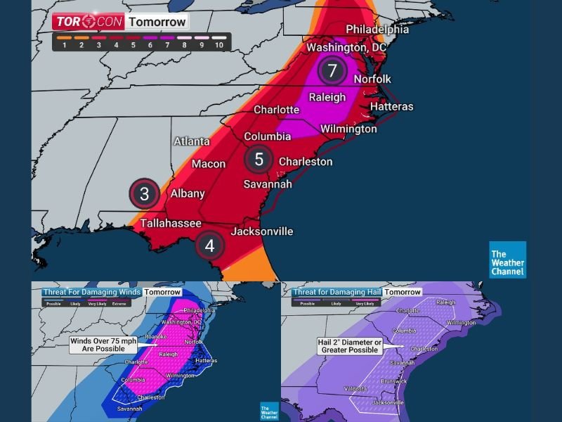
TORCON 7 Alert for Washington DC, North Carolina and South Carolina as Tornado Outbreak, 75+ MPH Winds and Large Hail Threaten Monday
WASHINGTON DC, NORTH CAROLINA AND SOUTH CAROLINA — A potentially dangerous severe weather outbreak is expected Monday across parts of the East Coast as meteorologists warn of a TORCON level 7 tornado threat, signaling an elevated chance for tornado development across the eastern Carolinas and Mid-Atlantic.
Forecasters say the storm system could bring multiple hazards including tornadoes, destructive wind gusts exceeding 75 miles per hour, and large hail, with storms possible from early morning through the evening as the system tracks northward along the East Coast. TORCON, a tornado probability scale that runs from 1 to 10, places Monday’s threat on the higher end of the scale across parts of the region.
Tornado Threat Extends From the Southeast Into the Mid-Atlantic
Meteorologists say the broader severe weather corridor may stretch from Panama City, Florida northward toward Ithaca, New York, though the most significant tornado risk currently appears centered across portions of the Carolinas and the Mid-Atlantic region.
Cities including Washington DC, Raleigh, Wilmington, Norfolk, and nearby communities could see storms capable of rotating and producing tornadoes as the system moves through. Because atmospheric instability is expected to increase through the day, storms that develop later in the afternoon could become stronger.
Highest Risk Focused Across Eastern Carolinas
Current forecasts place the highest tornado potential from the South Carolina Midlands through eastern North Carolina and toward the coastal plain.
Meteorologists say storms moving into this region later in the day could encounter the warmest and most unstable air of the event, increasing the chance that some storms could produce tornadoes.
Within this corridor, thunderstorms could organize into rotating cells capable of producing brief but potentially dangerous tornadoes. Forecasters stress that tornadoes may develop quickly within storm clusters and could occur at multiple points during the day.
Hurricane-Force Wind Gusts Possible Along East Coast Corridor
Along with the tornado threat, meteorologists say extreme wind gusts exceeding 75 miles per hour may develop across a large portion of the Mid-Atlantic and Southeast.
These winds could extend from Philadelphia and Harrisburg southward through Washington DC and along the Interstate 95 and Interstate 85 corridors into South Carolina.
Wind gusts of this magnitude can cause widespread damage by snapping trees, damaging structures, and knocking out power across large areas. Officials warn that storms capable of producing these winds could impact communities even outside of tornado-producing cells.
Large Hail Possible Across the Southeast
Another concern with Monday’s storm system is the potential for large hail measuring up to two inches in diameter, roughly the size of eggs. Forecasters say this hail threat may develop across areas stretching from the North Carolina Piedmont southward toward northern Florida.
Large hail can cause serious damage to vehicles, roofs, and outdoor structures if strong thunderstorms develop in these areas. Residents are encouraged to move vehicles under cover if severe storms approach.
Multiple Storm Rounds Possible Throughout Monday
Meteorologists say some communities could experience more than one round of storms as the system moves north through the region.
Initial storms may develop during the morning hours across parts of the Southeast before additional storms develop later in the afternoon and evening. Early timing projections suggest storms may reach Charlotte after 9 a.m., Raleigh after 7 a.m., and Greenville between 7 a.m. and 10 a.m., with impacts spreading north toward the Mid-Atlantic later in the day.
Cities including Norfolk, Washington DC, and Philadelphia could see severe weather during the afternoon or evening hours depending on how quickly the system moves.
Residents Urged to Prepare Ahead of Severe Weather
With a high-end TORCON 7 tornado threat and multiple severe weather hazards possible, officials are urging residents to remain alert and prepared. Having multiple ways to receive weather alerts is critical during severe weather events when tornado warnings may be issued with little notice.
Weather radios, smartphone alerts, and local broadcast updates are among the most reliable ways to receive warnings. Residents should also identify safe shelter locations and review safety plans ahead of Monday’s storms.
If severe weather impacts your community, share updates and local conditions with the newsroom at SaludaStandard-Sentinel.com so others across the region can stay informed as this major storm system develops.