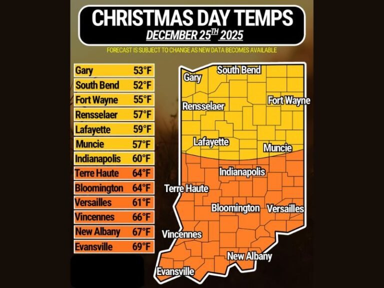
Illinois, Indiana and Midwest Brace for Explosive Weekend Storm as Deep Cyclone Brings Blizzard Snow and Severe Thunderstorms
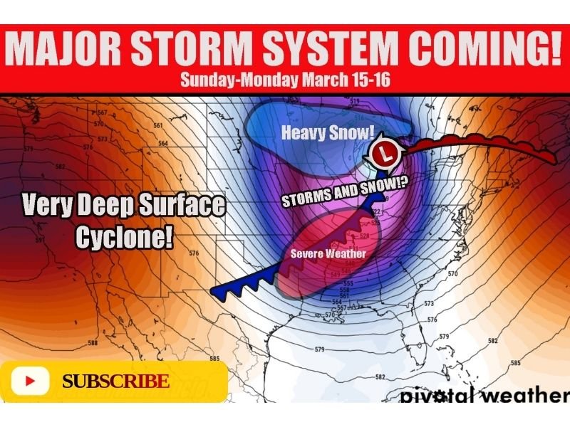
UNITED STATES — Meteorologists are tracking a powerful storm system expected to rapidly intensify across the central United States this weekend, potentially bringing a dangerous mix of blizzard conditions, heavy snowfall, and severe thunderstorms from the Plains into the Midwest. Forecast models show the system strengthening into a deep surface cyclone as it moves east Sunday into Monday, setting up a major weather divide across multiple states.
The developing storm is expected to impact a large portion of the country, with heavy snow forming on the colder northern side while strong thunderstorms and severe weather develop across the warmer southern side of the system.
Deepening Cyclone Expected to Drive a Major Weather Event
Weather models show the storm intensifying into what meteorologists describe as a very deep surface cyclone, a powerful low-pressure system capable of producing widespread impacts across multiple regions at once.
As the storm strengthens, the circulation around the low will draw cold air into the northern side of the system while warm, unstable air surges northward across the central United States. This sharp contrast in temperatures is expected to create a dramatic split in weather conditions across the Midwest.
Areas north of the storm’s track could experience widespread heavy snowfall and possible blizzard conditions, while states farther south could face thunderstorms capable of producing damaging winds and other severe weather hazards.
Heavy Snow and Possible Blizzard Conditions Across the Northern Tier
On the cold side of the storm system, forecasters expect heavy snow to develop across portions of the Upper Midwest and northern Plains.
As the low-pressure center intensifies and moves eastward, snow bands could expand across states near the Great Lakes, bringing accumulating snowfall and potentially hazardous travel conditions. Strong winds circulating around the deepening cyclone could combine with heavy snowfall to produce blowing snow and reduced visibility.
If these conditions align, parts of the northern Midwest could experience near-blizzard or full blizzard conditions as the storm reaches peak strength late Sunday into Monday.
Illinois and Indiana Could See a Messy Mix of Storms and Snow
One of the most complicated areas in the forecast lies across parts of northern Illinois and northern Indiana, where meteorologists say conditions may change rapidly as the storm system moves through. These areas could initially experience rain or thunderstorms as warm air surges northward ahead of the storm. However, as the system deepens and colder air wraps into the region, precipitation may transition into snow.
This type of rapid changeover can create particularly hazardous conditions on roads, as wet surfaces may quickly freeze while snowfall begins to accumulate. Forecasters describe the setup as potentially “messy,” with multiple types of precipitation occurring within a short time window.
Severe Thunderstorms Possible on the Warm Side of the Storm
While snow dominates the northern side of the system, the southern portion of the storm may bring a completely different threat.
Warm, unstable air ahead of the advancing cold front could allow thunderstorms to develop across parts of the central United States. Depending on how the atmosphere evolves, some of these storms could become severe. Potential hazards may include strong wind gusts, heavy rainfall, and isolated severe storms as the system pushes eastward.
Storm Timing and Potential Impacts
Forecast projections indicate the storm could begin organizing late Saturday before intensifying significantly Sunday and Monday. During this time, a large swath of the Midwest may experience rapidly changing weather conditions.
Because the storm is expected to strengthen quickly, meteorologists say forecast details — including the exact placement of heavy snow and severe weather — may shift over the coming days. Still, confidence is growing that this system will become one of the most significant weather events of the period, affecting travel and daily life across multiple states.
Residents across the Midwest are encouraged to stay updated on changing forecasts and prepare for potentially disruptive weather as the weekend approaches. Readers experiencing changing weather conditions across the Midwest can share updates, photos, or travel conditions with the community by visiting SaludaStandard-Sentinel.com.