Midwest Blizzard Alert: Minnesota and Wisconsin Brace for 2-Foot Snow, 50 MPH Winds as Winter Storm Iona Intensifies
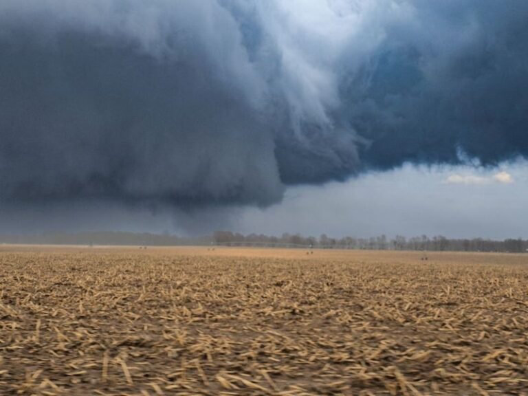
MINNEAPOLIS, MINNESOTA — A powerful late-season winter storm is rapidly organizing across the Midwest, and forecasters warn it could evolve into a full-scale blizzard as it sweeps from the Dakotas into Minnesota, Wisconsin, and parts of Michigan. Meteorologists say the system will intensify near the Great Lakes, producing extremely heavy snowfall rates and damaging wind gusts that could bring dangerous whiteout conditions across the region.
The storm, identified by meteorologists as Winter Storm Iona, is expected to begin impacting the region Sunday before reaching peak intensity Monday, with several major Midwest cities facing what could become their most significant snowfall event of the season.
Heavy Snow Expected From the Dakotas Through Michigan
Forecast models show a wide swath of accumulating snow stretching from the northern Plains into the Upper Midwest. Cities including Sioux Falls, Minneapolis, Duluth, and Green Bay lie directly in the path of the most intense snowfall.
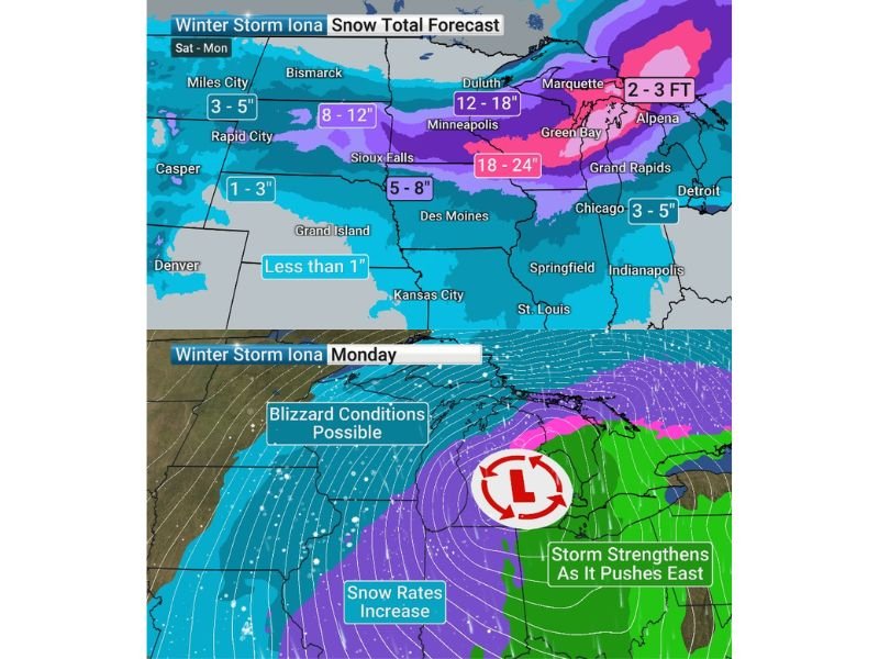
Snow totals could reach 8 to 12 inches across parts of the Dakotas and northern Minnesota, while the most severe impacts are expected in eastern Minnesota and much of Wisconsin. Forecast maps suggest Minneapolis may receive around 12 to 18 inches of snow, while communities closer to Lake Michigan could see even higher totals.
Meteorologists say snowfall rates may reach 1 to 3 inches per hour, a level capable of overwhelming road crews and rapidly covering highways. Combined with increasing winds, travel conditions could deteriorate quickly once the storm strengthens.
Blizzard Conditions Possible With 50 MPH Wind Gusts
As the storm system strengthens near the Great Lakes, the pressure gradient is expected to tighten significantly, allowing strong winds to develop across the Upper Midwest.
Forecasters warn that wind gusts between 30 and 50 mph could combine with the heavy snow to create full blizzard conditions in parts of Minnesota and Wisconsin. These winds could cause blowing and drifting snow, reducing visibility to near zero at times.
The combination of intense snowfall and strong winds means road travel may become extremely dangerous, especially Monday when the storm is projected to reach peak strength. In rural areas and open highways, whiteout conditions could develop rapidly.
Green Bay Could See a Historic Snowstorm
One of the most remarkable forecasts centers on northeastern Wisconsin. Current projections indicate Green Bay could receive up to 24 inches of snow, potentially making it the city’s biggest two-day snowfall event in well over a century.
Historical weather records suggest that if these projections verify, the storm could rival snowfall totals not seen since March of 1888, when nearly 29 inches fell during a powerful late-winter storm. While Green Bay is no stranger to heavy snow, meteorologists note that reaching two feet of accumulation in such a short window would place this event among the most significant in modern local weather history.
Storm Intensifies as It Pushes Toward the Great Lakes
Weather maps show the storm strengthening as it tracks eastward toward the Great Lakes. As the low-pressure center deepens, snowfall intensity is expected to increase across eastern Minnesota and Wisconsin.
At the same time, warmer air wrapping around the system may bring a mix of precipitation farther south, but the northern side of the storm will remain locked in colder air — allowing snow to fall continuously for many hours. This strengthening process is a key reason meteorologists believe the storm has the potential to generate widespread blizzard conditions.
Travel Disruptions Likely Across the Upper Midwest
Transportation officials across several states are already warning residents to prepare for major disruptions. Interstate highways across Minnesota and Wisconsin may experience hazardous driving conditions as heavy snow bands develop.
Air travel could also be affected at major hubs including Minneapolis–Saint Paul International Airport, where significant snowfall and strong winds could cause flight delays and cancellations. Emergency planners are urging residents to monitor forecasts closely and prepare for rapidly changing conditions as the storm approaches.
The coming storm is another reminder that winter weather can still pack a powerful punch even late in the season. Forecasts may continue to shift as the system develops, but the overall message from meteorologists remains clear: the Upper Midwest should prepare for a significant winter storm with potentially historic snowfall in some areas.
Readers following the storm across the Midwest can continue sharing updates, photos, or travel conditions with the community by visiting SaludaStandard-Sentinel.com.