Illinois Severe Weather Timeline: Tornado Risk South of I-80 While Chicago Area Faces Major Large Hail Threat Tuesday Night
ILLINOIS — Forecasters are warning that Tuesday’s weather across Illinois could evolve into a complex severe storm event, with tornado-producing supercells expected south of Interstate 80 while the Chicago metropolitan area faces a growing threat of large hail and numerous severe thunderstorms later in the evening.
Meteorologists have outlined a clear timeline showing how storms may develop through Tuesday afternoon and into early Wednesday morning, with the most intense activity expected during the evening and nighttime hours.
Quiet Start but Cold Air Settles Across Northern Illinois
Through the daytime hours Tuesday, conditions across northern Illinois are expected to remain relatively quiet. Cold air flowing off Lake Michigan will keep temperatures cooler across much of the region, with highs expected to remain in the 40s and 50s across northern Illinois, including the Chicago area.
While the calm conditions may give the impression that severe weather is unlikely, forecasters say the atmosphere will gradually become more unstable farther south.
Supercells Likely to Develop South of Interstate 80
Between 4 p.m. and 7 p.m., the first round of severe storms is expected to ignite south of Interstate 80, where the environment will be more favorable for strong thunderstorms.
These storms could quickly evolve into isolated supercells capable of producing tornadoes, large hail the size of golf balls or larger, and damaging winds.
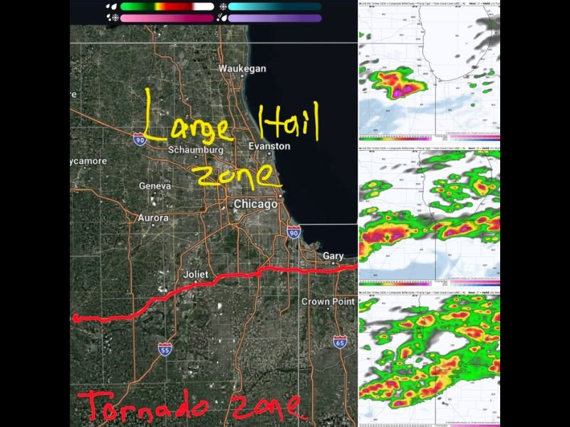
Areas potentially affected during this early phase include communities south of the Chicago metro region, including parts of central and southern Illinois. During this period, forecasters say most of the Chicago area north of I-80 will likely remain quiet, though storms will begin to organize and increase in number later in the evening.
Evening Brings Increased Severe Storm Coverage
From 7 p.m. until around midnight, severe storms are expected to become more widespread across parts of Illinois. South of Interstate 80, the tornado threat will remain the primary concern, as ongoing supercell thunderstorms continue to track across the region.
At the same time, storms may begin forming north of I-80 within colder air, spreading toward the Chicago metropolitan area. While the tornado risk is expected to remain low across the Chicago area, meteorologists warn that large hail could become a significant hazard, particularly if strong updrafts develop within the colder environment.
Forecasters say the region could see numerous severe thunderstorm warnings Tuesday night as storms move through the metro area.
Overnight Rain Continues Into Wednesday
After midnight and into Wednesday morning, the severe threat should gradually diminish as the main storm system moves through the region. Periods of rain are expected to continue overnight, though severe storms should weaken.
Some models suggest a brief mix of snow north of Interstate 80 early Wednesday morning, but meteorologists say the probability remains low and no snow accumulation is expected.
Residents Urged to Stay Weather Aware
Because the strongest storms may occur during the evening and nighttime hours, residents across Illinois are encouraged to stay alert for rapidly changing conditions.
Severe storms developing Tuesday evening could bring:
- Tornadoes in areas south of I-80
- Large hail across northern Illinois
- Damaging wind gusts
- Heavy rainfall and frequent lightning
Meteorologists stress that the situation will continue evolving throughout the day, and residents should monitor weather alerts closely.
Stay with SaludaStandard-Sentinel.com for continuing updates as forecasters track this developing severe weather threat across Illinois and the Midwest.