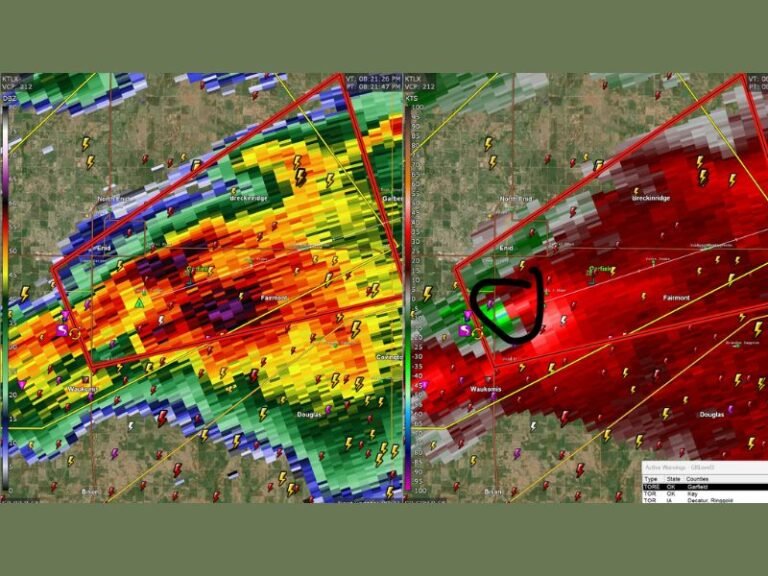
North Texas Could See Strong to Severe Thunderstorms Tuesday Evening as Atmospheric Cap Weakens Near Dallas and Wichita Falls
TEXAS — Meteorologists are closely monitoring a developing weather setup across North Texas that could allow strong to severe thunderstorms to form Tuesday evening as a key atmospheric barrier known as the “cap” weakens late in the day.
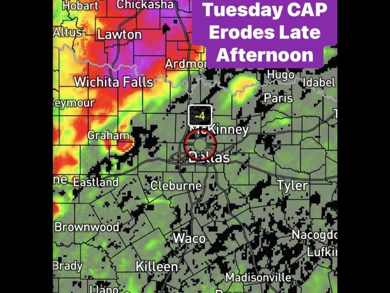
Forecast guidance indicates that during the early afternoon hours Tuesday, a strong atmospheric cap is expected to remain in place across much of North Texas, preventing storms from developing despite the presence of warm and unstable air.
However, weather models suggest that by around 5 p.m. local time, the cap could begin to erode, removing the barrier that has been suppressing storm development and allowing thunderstorms to rapidly form.
What the Atmospheric Cap Means for Storm Development
The “cap” refers to a layer of warm air in the atmosphere that acts like a lid, preventing rising air from forming thunderstorms. While the cap remains strong, storms typically cannot develop even when atmospheric conditions are otherwise favorable.
Forecasters say this is exactly what may happen across North Texas during the early part of Tuesday, when storm activity could remain limited through the midday hours. But once the cap weakens later in the afternoon, the atmosphere could become much more active.
Storms Could Rapidly Develop Late Tuesday
Weather model guidance suggests that the cap may fully erode by late afternoon, opening the door for thunderstorms to quickly develop across portions of the region.
Areas including Wichita Falls, Graham, Lawton, Ardmore, and Dallas–Fort Worth could see storm development once the atmospheric lid breaks.
If storms are able to form in this environment, meteorologists say they could strengthen quickly and potentially become severe due to the unstable air mass already present across North Texas.
Timing Will Be Key for Severe Weather Risk
Forecasters emphasize that the timing of the cap erosion will play a critical role in determining how widespread the storms become.
If the cap holds longer than expected, storm development could remain limited. However, if the cap weakens earlier or more rapidly, thunderstorms could form across a larger portion of the region. Meteorologists expect to refine the forecast further as updated data becomes available.
More Forecast Updates Expected
Weather experts say they will continue analyzing model guidance and atmospheric conditions ahead of Tuesday’s potential storm event. Additional forecast updates are expected as the short-range models come into clearer focus.
Residents across North Texas are encouraged to stay informed about changing weather conditions as the atmosphere becomes more favorable for thunderstorms later in the day.
If storms develop in your area, share photos and reports with SaludaStandard-Sentinel.com as we continue covering severe weather developments across the United States.