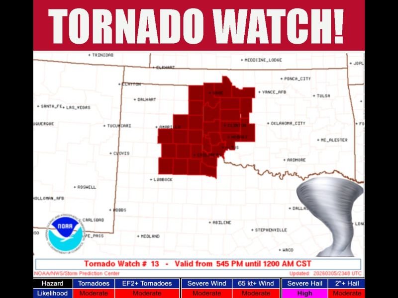
Tornado Watch Issued for Parts of Texas and Oklahoma as Supercell Storms Begin Developing Across the Southern Plains
TEXAS, OKLAHOMA — A Tornado Watch has been issued for portions of Texas and Oklahoma, with forecasters warning that developing thunderstorms could rapidly intensify into dangerous supercell storms capable of producing tornadoes, damaging winds, and large hail.
The watch remains in effect until midnight CST, as meteorologists monitor storm development across the Southern Plains.
Storms Beginning to Develop Across the Region
According to the latest weather briefing, storms are just beginning to initiate across the watch area and are expected to strengthen during the evening hours.
Once fully developed, these storms could organize into supercells — powerful rotating thunderstorms known for producing severe weather.
Meteorologists say the environment across the region is supportive of strong storm development, raising concerns about multiple severe hazards overnight.
Areas Included in the Tornado Watch
The Tornado Watch covers several counties across western Oklahoma and the Texas Panhandle region, including areas near:
- Clinton, Oklahoma
- Hobart, Oklahoma
- Elk City, Oklahoma
- Pampa, Texas
- Canadian, Texas
These areas fall within the core zone of the watch, where the potential for severe storms is highest as storms continue to organize.
Residents across the broader region are being urged to stay weather-aware throughout the evening.
Tornado and Severe Weather Risks
Forecast data associated with the watch indicates a moderate likelihood of tornadoes, including the potential for stronger EF2 or greater tornadoes.
Other major hazards include:
- Damaging winds exceeding 65 mph
- Large hail potentially larger than 2 inches in diameter
Meteorologists say large hail poses one of the most significant threats, with a high probability for hail capable of damaging vehicles, roofs, and crops.
Supercell Storms Could Intensify After Sunset
Weather experts note that storms developing late in the afternoon may strengthen rapidly after sunset, when atmospheric conditions become more favorable for rotating storms.
Supercells forming within the watch area may produce isolated tornadoes with little warning, making it important for residents to monitor alerts and warnings closely.
Emergency officials advise residents to have multiple ways to receive weather warnings, especially overnight when people may be sleeping.
Officials Urge Residents to Stay Prepared
With severe weather possible through the evening and into the night, officials recommend preparing a safety plan in case warnings are issued.
Residents in the watch area should identify safe shelter locations such as interior rooms, basements, or storm shelters, and stay updated through local weather alerts.
As storms continue to develop, forecasters will closely monitor conditions for possible tornado warnings or severe thunderstorm warnings. Have you experienced severe weather or tornado warnings in your area recently? Share your experience or weather photos with the community at SaludaStandard-Sentinel.com.