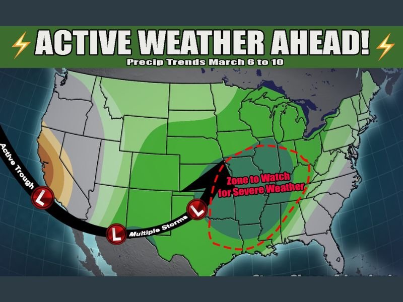
Multiple Storm Systems to Sweep Across Central and Southern U.S. March 6–10 as Active Trough Pattern Raises Severe Weather Concerns
UNITED STATES — A highly active weather pattern is setting up across the country, with multiple storm systems expected to move from the western United States into the Plains, Midwest, and South between March 6 and March 10.
Forecasters indicate that a deep trough developing in the western U.S. will trigger several rounds of precipitation. While exact timing and impacts are still uncertain, confidence is growing that widespread rainfall and potential severe weather will be part of the evolving pattern.
Western Trough to Fuel Multiple Storm Systems
Meteorologists highlight an intensifying trough along the West Coast as the primary driver of this unsettled stretch. As disturbances eject eastward, they are expected to develop into multiple low-pressure systems tracking across the central part of the country.
This setup is favorable for repeated rounds of rain and thunderstorms, particularly from Texas through the lower Mississippi Valley and into parts of the Midwest and Ohio Valley.
Zone to Watch for Severe Weather
Early projections suggest a corridor stretching from parts of the Southern Plains into the Mid-South and lower Ohio Valley could face the highest potential for stronger storms.
While it remains too soon to pinpoint specific outbreak days or hazards, severe weather — including strong thunderstorms — is considered possible within this active pattern. Forecasters stress that details regarding timing, storm intensity, and exact locations will become clearer as the event draws closer.
Heavy Rainfall Likely Across Several Regions
Beyond severe weather concerns, widespread rainfall appears likely across much of the central and eastern United States. With multiple storm systems in succession, some areas could experience repeated precipitation events over just a few days.
This may increase the risk of localized flooding, especially in regions that receive heavier rainfall from earlier storms in the sequence.
Forecast Details Still Developing
Meteorologists caution that while confidence is high in an active and wet pattern, specific day-by-day impacts are still being refined. Residents across the central and southern U.S. are encouraged to stay updated as forecast models continue to adjust in the coming days.
The March 6–10 period is shaping up to be notably unsettled, and additional advisories may be issued if severe weather risks become more defined.
Are you located in the potential impact zone? Share how preparations are shaping up in your area by visiting SaludaStandard-Sentinel.com and joining the conversation.