Midwest and Ohio Valley Bracing for 4+ Inches of Rain as WPC Forecast Shows Heavy Spring Soaker Stretching from Missouri to Pennsylvania
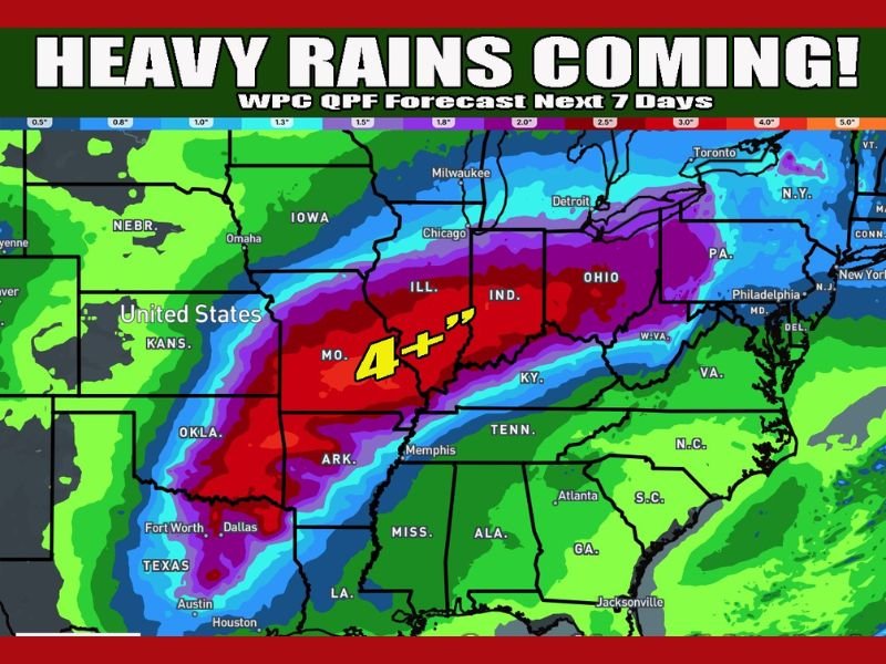
MIDWEST AND OHIO VALLEY — A widespread spring rain event is expected to drench a large portion of the central and eastern United States over the next seven days, with forecast models showing more than 4 inches of rain possible from Missouri through Indiana and Ohio into parts of Pennsylvania.
The latest Quantitative Precipitation Forecast (QPF) highlights a corridor of the heaviest rainfall stretching from eastern Oklahoma and Arkansas northeast through Illinois, Indiana, and Ohio. Some localized areas within this band could exceed four inches of total rainfall.
Heaviest Rainfall Focused Across Central States
The highest projected totals appear centered over portions of Missouri, southern Illinois, Indiana, and western Ohio. Deep red shading on the forecast map indicates areas where rainfall could surpass the 4-inch mark.
Additional heavy totals are also expected across eastern Texas and Arkansas, with significant rain spreading northeastward into the Ohio Valley.
Meteorologists note that while specific severe weather details remain uncertain, confidence is high that much of the region will experience repeated rounds of precipitation.
Northern Areas Could See Snow
While most of the precipitation will fall as rain, some northern areas near the Great Lakes and into parts of the Upper Midwest could see snow mixed in.
Temperature profiles will determine where rain transitions to wet snow, especially in higher elevations and farther north.
Flooding Concerns May Increase
With multiple rounds of rain expected over several days, flooding could become a concern in low-lying areas and along rivers and streams.
Urban areas in the heaviest rainfall corridor may also experience localized ponding and drainage issues if intense downpours develop.
Officials typically urge residents to monitor local forecasts and avoid driving through flooded roadways during prolonged rainfall events.
Spring Pattern Taking Shape
The forecast signals a broader seasonal shift toward a more active spring weather pattern. As moisture increases and storm systems move through more frequently, the risk for heavy rainfall events grows.
While the exact placement of the heaviest bands could still shift, the overall message remains clear: a soaking rain event is on the way for much of the Midwest and Ohio Valley.
How much rain is expected in your area? Share your local updates and weather impacts with us at SaludaStandard-Sentinel.com.