March Tornado Season Intensifies Across Mississippi and Ohio Valleys as Climatology Shows Highest Risk from Texas Through Dixie Alley
MISSISSIPPI VALLEY AND OHIO VALLEY — March has officially marked the beginning of tornado season across the central and southern United States, with climatology showing expanding risk from Texas through Dixie Alley and into parts of the Midwest.
As spring approaches, warmer air from the Gulf of Mexico begins pushing northward while the winter jet stream remains active across the southern tier of the country. This combination of increasing moisture, rising temperatures, and strong upper-level winds creates an environment favorable for severe thunderstorms and tornado development.
Why March Signals a Shift Toward Severe Weather
Meteorologists explain that March is often the first month when large-scale tornado outbreaks become more common. The seasonal transition allows warm, unstable air to clash with lingering cold systems sweeping in from the west.
Historical data referenced in the March tornado outlook shows that tornado activity typically increases and expands during this period. Fast-moving storm systems and deep trough patterns can trigger widespread severe weather across multiple states over several consecutive days.
The combination of strong wind shear and unstable air makes March particularly volatile, especially in the South and lower Midwest.
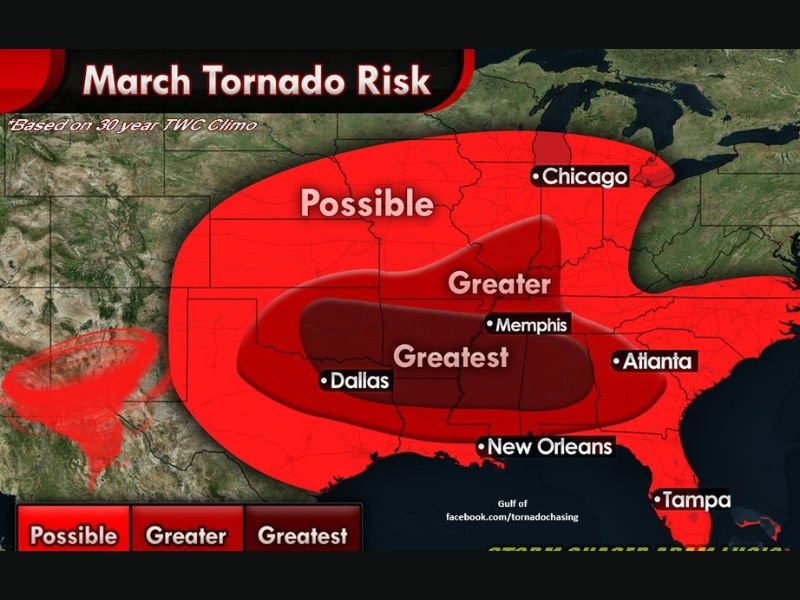
Dixie Alley Emerges as the Greatest Risk Zone
The highest historical concentration of March tornado activity is centered across eastern Texas, Louisiana, Arkansas, Mississippi, Alabama, and western Tennessee — a region commonly known as Dixie Alley .
Cities such as Dallas, Memphis, New Orleans, and Atlanta fall within the “Greater” to “Greatest” tornado risk zones based on 30-year climatology. These areas frequently experience rapid storm development when Gulf moisture surges northward and interacts with powerful frontal systems.
Farther north, the risk expands into the Ohio Valley and portions of the Midwest, including areas near Chicago, where March storms can still be potent despite cooler surface temperatures.
Fast-Moving Systems Can Produce Multi-State Outbreaks
One of the defining characteristics of March severe weather is the speed of storm systems. Deep digging troughs moving out of the western United States often intensify as they track eastward.
These setups can lead to fast-moving squall lines and supercell thunderstorms capable of producing damaging winds, large hail, and tornadoes. Because these systems cover large areas quickly, multiple states may experience severe weather within the same outbreak window.
Forecasters emphasize that while not every March system results in widespread tornadoes, the month historically serves as the opening chapter of peak spring severe weather season.
Preparedness Urged as Season Expands Northward
Emergency management agencies across the Mississippi and Ohio Valleys typically urge residents to review tornado safety plans as March begins. Officials recommend having multiple ways to receive warnings, identifying safe shelter areas, and staying alert during severe weather watches.
With atmospheric ingredients now aligning for increased activity, communities across the South and Midwest are entering a period where weather awareness becomes critical.
As tornado season unfolds, how are you preparing for potential severe weather this spring? Share your thoughts and experiences with us at SaludaStandard-Sentinel.com.